Campoverde geodata
Campoverde (Latium) is a populated place; located in Italy in Europe/Rome (GMT+2) time zone. With population of 809 people, there are 7607 cities with bigger population in this country. Compared to other cities in Italy, 74.5% of cities are located further ↑North; 65.4% of cities are located further ←West and 84.1% of cities have higher elevation than Campoverde. Note1


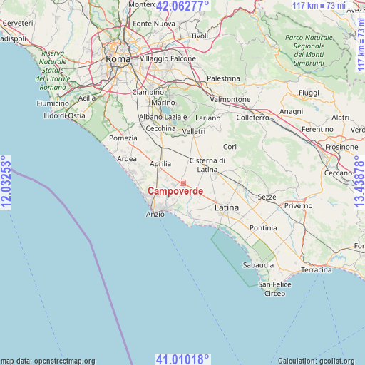
Campoverde GPS coordinates[2]
41° 32' 19.032" North, 12° 44' 8.34" East
| Map corner | latitude | longitude |
|---|---|---|
| Upper-left | 42.06277°, | 12.03253° |
| Center: | 41.53862°, | 12.73565° |
| Lower-right: | 41.01018°, | 13.43878° |
| Map W x H: | 117×117 km | = 72.7×72.7mi |
| max Lat: | 47.04031° ⇑74.5% North |
| Campoverde: | 41.53862° |
| min Lat: | ⇓25.5% South 35.50142° |
| min Long | Campoverde | max Long |
| 6.69888° | 12.73565° | 18.48682° |
| W 65.4%⇐ | ⇒34.6% E |
Elevation
Elevation of Campoverde is 34 m = 112 ft, and this is 272.7 m = 895 ft below average elevation for this country.
| Max E: |
2085 m = 6841 ft | 84.1% |
| Avg. | 306.7 m = 1006 ft | |
| Campoverde | 34 m = 112 ft | |
Min E: |
-4 m = -13 ft | 15.9% |
See also: Italy elevation on elevation.city.
Geographical zone
Campoverde is located in North temperate zone (between Tropic of Cancer and the Arctic Circle). Distance of this Northern Tropic circle is 2012.7 km =1250.6 mi to South.| Distance of | km | miles | from Campoverde |
|---|---|---|---|
| North Pole | 5388.4 | 3348.2 | to North |
| Arctic Circle | 2782.5 | 1729 | to North |
| Tropic Cancer | 2012.7 | 1250.6 | to South |
| Equator | 4618.7 | 2869.9 | to South |


Nearby cities:
15 places around Campoverde: (largest is in red/bold)
• Aprilia
9.2 km =5.7 mi,  312°
312°
• Bellavista
11.4 km =7.1 mi,  324°
324°
• Borgo Bainsizza
7.8 km =4.8 mi,  141°
141°
• Borgo Flora
8 km =5 mi,  81°
81°
• Borgo Montello
4.5 km =2.8 mi,  133°
133°
• Borgo Podgora
10.2 km =6.3 mi,  105°
105°
• Borgo Santa Maria
10 km =6.2 mi,  148°
148°
• Camilleri-Vallelata
11.9 km =7.4 mi,  304°
304°
• Campo di Carne
8 km =5 mi,  281°
281°
• Cisterna di Latina
9.6 km =6 mi,  52°
52°
• Crocefisso
11.1 km =6.9 mi, 136°
• Genio Civile
3.8 km =2.4 mi,  285°
285°
• Landi-Pedica
11.5 km =7.1 mi,  351°
351°
• Nettuno
10.8 km =6.7 mi,  213°
213°
• Spadellata
10.4 km =6.5 mi,  261°
261°
Sources, notices
• [Note1] Compared only with cities in Italy existing in our database
• [Src1] Map data: © OpenStreetMap contributors (CC-BY-SA)
• [Src2] Other city data from geonames.org with taken over terms of usage.
• [Src3] Geographical zone / Annual Mean Temperature by Robert A. Rohde @ Wikipedia
