Antey-Saint-Andrè geodata
Antey-Saint-Andrè (Aosta Valley) is a seat of a third-order administrative division; located in Italy in Europe/Rome (GMT+2) time zone. With population of 247 people, there are 10903 cities with bigger population in this country. Compared to other cities in Italy, 86% of cities are located further ↓South; 97.2% of cities are located further →East and 97.5% of cities have lower elevation than Antey-Saint-Andrè. Note1


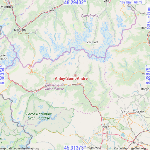
Antey-Saint-Andrè GPS coordinates[2]
45° 48' 21.708" North, 7° 35' 11.976" East
| Map corner | latitude | longitude |
|---|---|---|
| Upper-left | 46.29402°, | 6.88354° |
| Center: | 45.80603°, | 7.58666° |
| Lower-right: | 45.31373°, | 8.28979° |
| Map W x H: | 109×109 km | = 67.7×67.7mi |
| max Lat: | 47.04031° ⇑14% North |
| Antey-Saint-Andrè: | 45.80603° |
| min Lat: | ⇓86% South 35.50142° |
| min Long | Antey-Saint-And | max Long |
| 6.69888° | 7.58666° | 18.48682° |
| W 2.8%⇐ | ⇒97.2% E |
Elevation
Elevation of Antey-Saint-Andrè is 1038 m = 3406 ft, and this is 731.3 m = 2399 ft above average elevation for this country.
| Max E: |
2085 m = 6841 ft | 2.5% |
| Antey-Saint-Andrè | 1038 m 3406 ft | |
| Avg. | 306.7 m = 1006 ft | |
Min E: |
-4 m = -13 ft | 97.5% |
See also: Italy elevation on elevation.city.
Geographical zone
Antey-Saint-Andrè is located in North temperate zone (between Tropic of Cancer and the Arctic Circle). Distance of this North polar circle is 2308 km =1434.1 mi to North.| Distance of | km | miles | from Antey-Saint-Andrè |
|---|---|---|---|
| North Pole | 4913.9 | 3053.4 | to North |
| Arctic Circle | 2308 | 1434.1 | to North |
| Tropic Cancer | 2487.2 | 1545.5 | to South |
| Equator | 5093.2 | 3164.8 | to South |


Nearby cities:
15 places around Antey-Saint-Andrè: (largest is in red/bold)
• Antagnod
8 km =5 mi,  82°
82°
• Ayas
8 km =5 mi, 82°
• Chambave
7.5 km =4.7 mi,  202°
202°
• Chamois
4.4 km =2.7 mi,  34°
34°
• Chatillon
6.7 km =4.2 mi,  159°
159°
• La Magdeleine
2.5 km =1.6 mi, 80°
• Lassolaz
7.5 km =4.7 mi,  178°
178°
• Mongnod
1.4 km =0.9 mi,  267°
267°
• Paquier
8.6 km =5.3 mi,  20°
20°
• Pontey
7.5 km =4.7 mi, 179°
• Saint-Denis
6.4 km =4 mi, 202°
• Saint-Vincent
7.8 km =4.8 mi,  142°
142°
• Torgnon
1.3 km =0.8 mi, 270°
• Valtournenche
8.3 km =5.2 mi, 20°
• Verrayes
6.2 km =3.9 mi,  220°
220°
In other languages:
- In France: Antey-Saint-André
- In German: Antey-Saint-André
- In Italian: Antey-Saint-André
Sources, notices
• [Note1] Compared only with cities in Italy existing in our database
• [Src1] Map data: © OpenStreetMap contributors (CC-BY-SA)
• [Src2] Other city data from geonames.org with taken over terms of usage.
• [Src3] Geographical zone / Annual Mean Temperature by Robert A. Rohde @ Wikipedia
