Lassolaz geodata
Lassolaz (Aosta Valley) is a seat of a third-order administrative division; located in Italy in Europe/Rome (GMT+2) time zone. With population of 596 people, there are 9051 cities with bigger population in this country. Compared to other cities in Italy, 83% of cities are located further ↓South; 97.2% of cities are located further →East and 80.1% of cities have lower elevation than Lassolaz. Note1


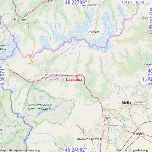
Lassolaz GPS coordinates[2]
45° 44' 18.636" North, 7° 35' 19.788" East
| Map corner | latitude | longitude |
|---|---|---|
| Upper-left | 46.22709°, | 6.88571° |
| Center: | 45.73851°, | 7.58883° |
| Lower-right: | 45.24562°, | 8.29196° |
| Map W x H: | 109.1×109.1 km | = 67.8×67.8mi |
| max Lat: | 47.04031° ⇑17% North |
| Lassolaz: | 45.73851° |
| min Lat: | ⇓83% South 35.50142° |
| min Long | Lassolaz | max Long |
| 6.69888° | 7.58883° | 18.48682° |
| W 2.8%⇐ | ⇒97.2% E |
Elevation
Elevation of Lassolaz is 527 m = 1729 ft, and this is 220.3 m = 723 ft above average elevation for this country.
| Max E: |
2085 m = 6841 ft | 19.9% |
| Lassolaz | 527 m 1729 ft | |
| Avg. | 306.7 m = 1006 ft | |
Min E: |
-4 m = -13 ft | 80.1% |
See also: Italy elevation on elevation.city.
Geographical zone
Lassolaz is located in North temperate zone (between Tropic of Cancer and the Arctic Circle). Distance of this North polar circle is 2315.5 km =1438.8 mi to North.| Distance of | km | miles | from Lassolaz |
|---|---|---|---|
| North Pole | 4921.4 | 3058 | to North |
| Arctic Circle | 2315.5 | 1438.8 | to North |
| Tropic Cancer | 2479.7 | 1540.8 | to South |
| Equator | 5085.6 | 3160 | to South |


Nearby cities:
15 places around Lassolaz: (largest is in red/bold)
• Antey-Saint-Andrè
7.5 km =4.7 mi,  358°
358°
• Berriat
7.6 km =4.7 mi,  117°
117°
• Chambave
3.1 km =1.9 mi,  281°
281°
• Champdepraz
7.9 km =4.9 mi,  138°
138°
• Chatillon
2.5 km =1.6 mi,  59°
59°
• Emarese
8 km =5 mi,  100°
100°
• Fénis
7.3 km =4.5 mi,  266°
266°
• La Magdeleine
8.3 km =5.2 mi,  16°
16°
• Mongnod
7.6 km =4.7 mi,  347°
347°
• Montjovet
7.4 km =4.6 mi, 117°
• Pontey
0.1 km =0.1 mi,  313°
313°
• Saint-Denis
3 km =1.9 mi,  300°
300°
• Saint-Vincent
4.8 km =3 mi,  73°
73°
• Torgnon
7.7 km =4.8 mi, 348°
• Verrayes
5 km =3.1 mi, 303°
Sources, notices
• [Note1] Compared only with cities in Italy existing in our database
• [Src1] Map data: © OpenStreetMap contributors (CC-BY-SA)
• [Src2] Other city data from geonames.org with taken over terms of usage.
• [Src3] Geographical zone / Annual Mean Temperature by Robert A. Rohde @ Wikipedia
