Taino geodata
Taino (Lombardy) is a seat of a third-order administrative division; located in Italy in Europe/Rome (GMT+2) time zone. With population of 3,706 people, there are 2552 cities with bigger population in this country. Compared to other cities in Italy, 84.1% of cities are located further ↓South; 86.5% of cities are located further →East and 54.3% of cities have lower elevation than Taino. Note1


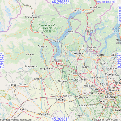
Taino GPS coordinates[2]
45° 45' 44.964" North, 8° 36' 59.544" East
| Map corner | latitude | longitude |
|---|---|---|
| Upper-left | 46.25086°, | 7.91342° |
| Center: | 45.76249°, | 8.61654° |
| Lower-right: | 45.26981°, | 9.31967° |
| Map W x H: | 109.1×109.1 km | = 67.8×67.8mi |
| max Lat: | 47.04031° ⇑15.9% North |
| Taino: | 45.76249° |
| min Lat: | ⇓84.1% South 35.50142° |
| min Long | Taino | max Long |
| 6.69888° | 8.61654° | 18.48682° |
| W 13.5%⇐ | ⇒86.5% E |
Elevation
Elevation of Taino is 261 m = 856 ft, and this is 45.7 m = 150 ft below average elevation for this country.
| Max E: |
2085 m = 6841 ft | 45.7% |
| Avg. | 306.7 m = 1006 ft | |
| Taino | 261 m = 856 ft | |
Min E: |
-4 m = -13 ft | 54.3% |
See also: Italy elevation on elevation.city.
Geographical zone
Taino is located in North temperate zone (between Tropic of Cancer and the Arctic Circle). Distance of this North polar circle is 2312.9 km =1437.2 mi to North.| Distance of | km | miles | from Taino |
|---|---|---|---|
| North Pole | 4918.8 | 3056.4 | to North |
| Arctic Circle | 2312.9 | 1437.2 | to North |
| Tropic Cancer | 2482.4 | 1542.5 | to South |
| Equator | 5088.3 | 3161.7 | to South |


Nearby cities:
15 places around Taino: (largest is in red/bold)
• Angera
3.3 km =2.1 mi,  296°
296°
• Arona
4.6 km =2.9 mi,  265°
265°
• Cadrezzate
4.6 km =2.9 mi,  26°
26°
• Castelletto Sopra Ticino
4.9 km =3 mi,  164°
164°
• Comabbio
4.9 km =3 mi,  75°
75°
• Comignago
6.7 km =4.2 mi,  217°
217°
• Corgeno
5.8 km =3.6 mi,  108°
108°
• Dormelletto
4.8 km =3 mi,  233°
233°
• Ispra
5.8 km =3.6 mi,  357°
357°
• Lisanza
2.9 km =1.8 mi,  208°
208°
• Mercallo
4.5 km =2.8 mi, 111°
• Osmate
4.2 km =2.6 mi,  45°
45°
• Ranco
5.2 km =3.2 mi,  317°
317°
• Sesto Calende
4.3 km =2.7 mi, 161°
• Travedona Monate
6.3 km =3.9 mi,  42°
42°
Sources, notices
• [Note1] Compared only with cities in Italy existing in our database
• [Src1] Map data: © OpenStreetMap contributors (CC-BY-SA)
• [Src2] Other city data from geonames.org with taken over terms of usage.
• [Src3] Geographical zone / Annual Mean Temperature by Robert A. Rohde @ Wikipedia
