Anfo geodata
Anfo (Lombardy) is a seat of a third-order administrative division; located in Italy in Europe/Rome (GMT+2) time zone. With population of 390 people, there are 10322 cities with bigger population in this country. Compared to other cities in Italy, 84.3% of cities are located further ↓South; 62.9% of cities are located further →East and 68.7% of cities have lower elevation than Anfo. Note1


Anfo GPS coordinates[2]
45° 45' 56.7" North, 10° 29' 37.752" East
| Map corner | latitude | longitude |
|---|---|---|
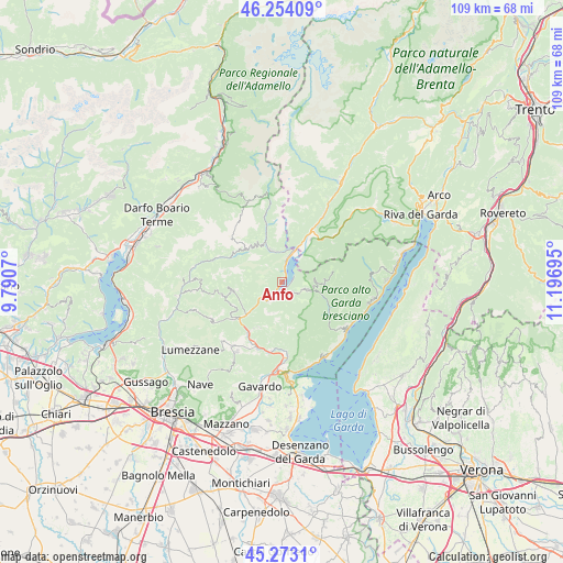
| Upper-left | 46.25409°, | 9.7907° |
| Center: | 45.76575°, | 10.49382° |
| Lower-right: | 45.2731°, | 11.19695° |
| Map W x H: | 109.1×109.1 km | = 67.8×67.8mi |
| max Lat: | 47.04031° ⇑15.7% North |
| Anfo: | 45.76575° |
| min Lat: | ⇓84.3% South 35.50142° |
| min Long | Anfo | max Long |
| 6.69888° | 10.49382° | 18.48682° |
| W 37.1%⇐ | ⇒62.9% E |
Elevation
Elevation of Anfo is 381 m = 1250 ft, and this is 74.3 m = 244 ft above average elevation for this country.
| Max E: |
2085 m = 6841 ft | 31.3% |
| Anfo | 381 m 1250 ft | |
| Avg. | 306.7 m = 1006 ft | |
Min E: |
-4 m = -13 ft | 68.7% |
See also: Italy elevation on elevation.city.
Geographical zone
Anfo is located in North temperate zone (between Tropic of Cancer and the Arctic Circle). Distance of this North polar circle is 2312.5 km =1436.9 mi to North.| Distance of | km | miles | from Anfo |
|---|---|---|---|
| North Pole | 4918.4 | 3056.2 | to North |
| Arctic Circle | 2312.5 | 1436.9 | to North |
| Tropic Cancer | 2482.8 | 1542.7 | to South |
| Equator | 5088.7 | 3162 | to South |


Nearby cities:
15 places around Anfo: (largest is in red/bold)
• Bagolino
7.1 km =4.4 mi,  339°
339°
• Bondone
6.3 km =3.9 mi,  44°
44°
• Capovalle
4.2 km =2.6 mi,  109°
109°
• Cedessano
9.8 km =6.1 mi,  208°
208°
• Crone
3.5 km =2.2 mi,  204°
204°
• Idro
3.7 km =2.3 mi, 205°
• Lavenone
5.2 km =3.2 mi,  234°
234°
• Lodrone-Darzo
7.8 km =4.8 mi,  24°
24°
• Magasa
9.6 km =6 mi,  79°
79°
• Pertica Bassa
9.5 km =5.9 mi,  261°
261°
• Ponte Caffaro
6.6 km =4.1 mi, 22°
• Provaglio Val Sabbia
9.7 km =6 mi, 208°
• Trebbio
6.4 km =4 mi, 203°
• Valvestino
7.9 km =4.9 mi,  94°
94°
• Vestone
9.9 km =6.2 mi, 229°
Sources, notices
• [Note1] Compared only with cities in Italy existing in our database
• [Src1] Map data: © OpenStreetMap contributors (CC-BY-SA)
• [Src2] Other city data from geonames.org with taken over terms of usage.
• [Src3] Geographical zone / Annual Mean Temperature by Robert A. Rohde @ Wikipedia
