Capovalle geodata
Capovalle (Lombardy) is a seat of a third-order administrative division; located in Italy in Europe/Rome (GMT+2) time zone. With population of 257 people, there are 10860 cities with bigger population in this country. Compared to other cities in Italy, 83.7% of cities are located further ↓South; 62.3% of cities are located further →East and 95.5% of cities have lower elevation than Capovalle. Note1


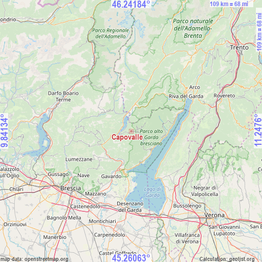
Capovalle GPS coordinates[2]
45° 45' 12.204" North, 10° 32' 40.092" East
| Map corner | latitude | longitude |
|---|---|---|
| Upper-left | 46.24184°, | 9.84134° |
| Center: | 45.75339°, | 10.54447° |
| Lower-right: | 45.26063°, | 11.2476° |
| Map W x H: | 109.1×109.1 km | = 67.8×67.8mi |
| max Lat: | 47.04031° ⇑16.3% North |
| Capovalle: | 45.75339° |
| min Lat: | ⇓83.7% South 35.50142° |
| min Long | Capovalle | max Long |
| 6.69888° | 10.54447° | 18.48682° |
| W 37.7%⇐ | ⇒62.3% E |
Elevation
Elevation of Capovalle is 902 m = 2959 ft, and this is 595.3 m = 1953 ft above average elevation for this country.
| Max E: |
2085 m = 6841 ft | 4.5% |
| Capovalle | 902 m 2959 ft | |
| Avg. | 306.7 m = 1006 ft | |
Min E: |
-4 m = -13 ft | 95.5% |
See also: Italy elevation on elevation.city.
Geographical zone
Capovalle is located in North temperate zone (between Tropic of Cancer and the Arctic Circle). Distance of this North polar circle is 2313.9 km =1437.8 mi to North.| Distance of | km | miles | from Capovalle |
|---|---|---|---|
| North Pole | 4919.8 | 3057 | to North |
| Arctic Circle | 2313.9 | 1437.8 | to North |
| Tropic Cancer | 2481.4 | 1541.9 | to South |
| Equator | 5087.3 | 3161.1 | to South |


Nearby cities:
15 places around Capovalle: (largest is in red/bold)
• Anfo
4.2 km =2.6 mi,  289°
289°
• Bagolino
10.2 km =6.3 mi,  321°
321°
• Bondone
5.9 km =3.7 mi,  4°
4°
• Cedessano
11.2 km =7 mi,  229°
229°
• Crone
5.7 km =3.5 mi,  251°
251°
• Gargnano
11.6 km =7.2 mi,  130°
130°
• Idro
5.8 km =3.6 mi, 250°
• Lavenone
8.3 km =5.2 mi,  258°
258°
• Lodrone-Darzo
8.5 km =5.3 mi,  355°
355°
• Magasa
6.4 km =4 mi,  60°
60°
• Ponte Caffaro
7.6 km =4.7 mi,  349°
349°
• Provaglio Val Sabbia
11.2 km =7 mi, 230°
• Storo
11 km =6.8 mi,  14°
14°
• Trebbio
7.9 km =4.9 mi,  235°
235°
• Valvestino
4 km =2.5 mi,  78°
78°
Sources, notices
• [Note1] Compared only with cities in Italy existing in our database
• [Src1] Map data: © OpenStreetMap contributors (CC-BY-SA)
• [Src2] Other city data from geonames.org with taken over terms of usage.
• [Src3] Geographical zone / Annual Mean Temperature by Robert A. Rohde @ Wikipedia
