Anagni geodata
Anagni (Latium) is a seat of a third-order administrative division; located in Italy in Europe/Rome (GMT+2) time zone. With population of 9,206 people, there are 1030 cities with bigger population in this country. Compared to other cities in Italy, 72.4% of cities are located further ↑North; 70% of cities are located further ←West and 72.6% of cities have lower elevation than Anagni. Note1


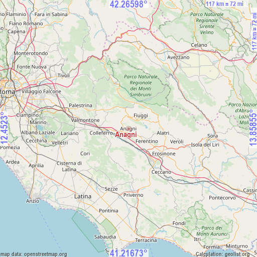
Anagni GPS coordinates[2]
41° 44' 36.6" North, 13° 9' 19.512" East
| Map corner | latitude | longitude |
|---|---|---|
| Upper-left | 42.26598°, | 12.4523° |
| Center: | 41.7435°, | 13.15542° |
| Lower-right: | 41.21673°, | 13.85855° |
| Map W x H: | 116.7×116.7 km | = 72.5×72.5mi |
| max Lat: | 47.04031° ⇑72.4% North |
| Anagni: | 41.7435° |
| min Lat: | ⇓27.6% South 35.50142° |
| min Long | Anagni | max Long |
| 6.69888° | 13.15542° | 18.48682° |
| W 70%⇐ | ⇒30% E |
Elevation
Elevation of Anagni is 421 m = 1381 ft, and this is 114.3 m = 375 ft above average elevation for this country.
| Max E: |
2085 m = 6841 ft | 27.4% |
| Anagni | 421 m 1381 ft | |
| Avg. | 306.7 m = 1006 ft | |
Min E: |
-4 m = -13 ft | 72.6% |
See also: Italy elevation on elevation.city.
Geographical zone
Anagni is located in North temperate zone (between Tropic of Cancer and the Arctic Circle). Distance of this Northern Tropic circle is 2035.5 km =1264.8 mi to South.| Distance of | km | miles | from Anagni |
|---|---|---|---|
| North Pole | 5365.6 | 3334 | to North |
| Arctic Circle | 2759.7 | 1714.8 | to North |
| Tropic Cancer | 2035.5 | 1264.8 | to South |
| Equator | 4641.4 | 2884 | to South |


Nearby cities:
15 places around Anagni: (largest is in red/bold)
• Acuto
5.5 km =3.4 mi,  16°
16°
• Ferentino
10.2 km =6.3 mi,  124°
124°
• Fiuggi
8.3 km =5.2 mi,  43°
43°
• Fumone
9.6 km =6 mi,  95°
95°
• Gavignano
10 km =6.2 mi,  240°
240°
• Madonna delle Grazie Iacp
1.1 km =0.7 mi,  194°
194°
• Osteria della Fontana
1.9 km =1.2 mi,  211°
211°
• Paliano
7.7 km =4.8 mi,  301°
301°
• Piglio
9.8 km =6.1 mi,  349°
349°
• San Giovanni-Patoni
10.4 km =6.5 mi,  72°
72°
• Sgurgola
8.3 km =5.2 mi,  183°
183°
• Tofe
8.5 km =5.3 mi,  140°
140°
• Torre Caietani
10.3 km =6.4 mi,  62°
62°
• Trivigliano
10.3 km =6.4 mi, 69°
• Tufano
4.5 km =2.8 mi,  108°
108°
Sources, notices
• [Note1] Compared only with cities in Italy existing in our database
• [Src1] Map data: © OpenStreetMap contributors (CC-BY-SA)
• [Src2] Other city data from geonames.org with taken over terms of usage.
• [Src3] Geographical zone / Annual Mean Temperature by Robert A. Rohde @ Wikipedia
