Piglio geodata
Piglio (Latium) is a seat of a third-order administrative division; located in Italy in Europe/Rome (GMT+2) time zone. With population of 3,399 people, there are 2757 cities with bigger population in this country. Compared to other cities in Italy, 71.8% of cities are located further ↑North; 69.7% of cities are located further ←West and 85.4% of cities have lower elevation than Piglio. Note1


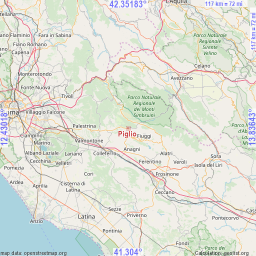
Piglio GPS coordinates[2]
41° 49' 48.216" North, 13° 7' 59.88" East
| Map corner | latitude | longitude |
|---|---|---|
| Upper-left | 42.35183°, | 12.43018° |
| Center: | 41.83006°, | 13.1333° |
| Lower-right: | 41.304°, | 13.83643° |
| Map W x H: | 116.5×116.5 km | = 72.4×72.4mi |
| max Lat: | 47.04031° ⇑71.8% North |
| Piglio: | 41.83006° |
| min Lat: | ⇓28.2% South 35.50142° |
| min Long | Piglio | max Long |
| 6.69888° | 13.1333° | 18.48682° |
| W 69.7%⇐ | ⇒30.3% E |
Elevation
Elevation of Piglio is 621 m = 2037 ft, and this is 314.3 m = 1031 ft above average elevation for this country.
| Max E: |
2085 m = 6841 ft | 14.6% |
| Piglio | 621 m 2037 ft | |
| Avg. | 306.7 m = 1006 ft | |
Min E: |
-4 m = -13 ft | 85.4% |
See also: Italy elevation on elevation.city.
Geographical zone
Piglio is located in North temperate zone (between Tropic of Cancer and the Arctic Circle). Distance of this Northern Tropic circle is 2045.1 km =1270.8 mi to South.| Distance of | km | miles | from Piglio |
|---|---|---|---|
| North Pole | 5356 | 3328.1 | to North |
| Arctic Circle | 2750.1 | 1708.8 | to North |
| Tropic Cancer | 2045.1 | 1270.8 | to South |
| Equator | 4651.1 | 2890.1 | to South |


Nearby cities:
15 places around Piglio: (largest is in red/bold)
• Acuto
5.5 km =3.4 mi,  141°
141°
• Affile
6.7 km =4.2 mi,  334°
334°
• Anagni
9.8 km =6.1 mi,  169°
169°
• Arcinazzo Romano
5.7 km =3.5 mi,  344°
344°
• Bellegra
10.4 km =6.5 mi,  303°
303°
• Fiuggi
8.3 km =5.2 mi,  115°
115°
• Jenne
7.2 km =4.5 mi,  24°
24°
• La Forma
3.5 km =2.2 mi,  277°
277°
• Madonna delle Grazie Iacp
10.8 km =6.7 mi, 171°
• Olevano Romano
8.7 km =5.4 mi,  291°
291°
• Osteria della Fontana
11.3 km =7 mi,  175°
175°
• Paliano
7.3 km =4.5 mi,  220°
220°
• Roiate
7.3 km =4.5 mi,  310°
310°
• Serrone
3.4 km =2.1 mi, 293°
• Trevi nel Lazio
10.2 km =6.3 mi,  69°
69°
Sources, notices
• [Note1] Compared only with cities in Italy existing in our database
• [Src1] Map data: © OpenStreetMap contributors (CC-BY-SA)
• [Src2] Other city data from geonames.org with taken over terms of usage.
• [Src3] Geographical zone / Annual Mean Temperature by Robert A. Rohde @ Wikipedia
