Amatrice geodata
Amatrice (Latium) is a seat of a third-order administrative division; located in Italy in Europe/Rome (GMT+2) time zone. With population of 1,046 people, there are 6479 cities with bigger population in this country. Compared to other cities in Italy, 65.6% of cities are located further ↑North; 71.3% of cities are located further ←West and 96.5% of cities have lower elevation than Amatrice. Note1


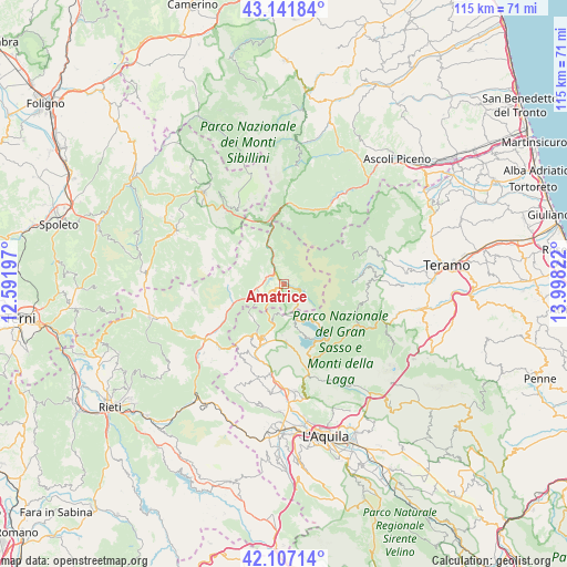
Amatrice GPS coordinates[2]
42° 37' 35.904" North, 13° 17' 42.324" East
| Map corner | latitude | longitude |
|---|---|---|
| Upper-left | 43.14184°, | 12.59197° |
| Center: | 42.62664°, | 13.29509° |
| Lower-right: | 42.10714°, | 13.99822° |
| Map W x H: | 115×115 km | = 71.5×71.5mi |
| max Lat: | 47.04031° ⇑65.6% North |
| Amatrice: | 42.62664° |
| min Lat: | ⇓34.4% South 35.50142° |
| min Long | Amatrice | max Long |
| 6.69888° | 13.29509° | 18.48682° |
| W 71.3%⇐ | ⇒28.7% E |
Elevation
Elevation of Amatrice is 960 m = 3150 ft, and this is 653.3 m = 2143 ft above average elevation for this country.
| Max E: |
2085 m = 6841 ft | 3.5% |
| Amatrice | 960 m 3150 ft | |
| Avg. | 306.7 m = 1006 ft | |
Min E: |
-4 m = -13 ft | 96.5% |
See also: Italy elevation on elevation.city.
Geographical zone
Amatrice is located in North temperate zone (between Tropic of Cancer and the Arctic Circle). Distance of this Northern Tropic circle is 2133.7 km =1325.8 mi to South.| Distance of | km | miles | from Amatrice |
|---|---|---|---|
| North Pole | 5267.4 | 3273 | to North |
| Arctic Circle | 2661.5 | 1653.8 | to North |
| Tropic Cancer | 2133.7 | 1325.8 | to South |
| Equator | 4739.6 | 2945 | to South |


Nearby cities:
15 places around Amatrice: (largest is in red/bold)
• Accumoli
8.5 km =5.3 mi,  332°
332°
• Acquasanta Terme
18.8 km =11.7 mi,  31°
31°
• Arquata del Tronto
16.1 km =10 mi,  359°
359°
• Barete
19.7 km =12.2 mi,  183°
183°
• Borbona
18.7 km =11.6 mi,  225°
225°
• Cagnano Amiterno
19.6 km =12.2 mi,  196°
196°
• Campotosto
9.6 km =6 mi,  141°
141°
• Capitignano
11.8 km =7.3 mi, 177°
• Cittareale
11.3 km =7 mi,  264°
264°
• Cortino
17.4 km =10.8 mi,  91°
91°
• Crognaleto
16.4 km =10.2 mi,  105°
105°
• Marana
15.6 km =9.7 mi, 202°
• Montereale
12.2 km =7.6 mi, 199°
• Nerito
17.3 km =10.7 mi,  120°
120°
• Paggese-Santa Maria
19.6 km =12.2 mi, 30°
Sources, notices
• [Note1] Compared only with cities in Italy existing in our database
• [Src1] Map data: © OpenStreetMap contributors (CC-BY-SA)
• [Src2] Other city data from geonames.org with taken over terms of usage.
• [Src3] Geographical zone / Annual Mean Temperature by Robert A. Rohde @ Wikipedia
