Nerito geodata
Nerito (Abruzzo) is a seat of a third-order administrative division; located in Italy in Europe/Rome (GMT+2) time zone. With population of 354 people, there are 10463 cities with bigger population in this country. Compared to other cities in Italy, 66% of cities are located further ↑North; 73.3% of cities are located further ←West and 94.1% of cities have lower elevation than Nerito. Note1


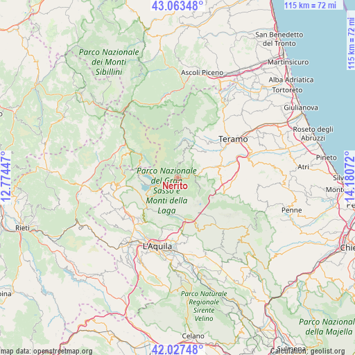
Nerito GPS coordinates[2]
42° 32' 51.468" North, 13° 28' 39.324" East
| Map corner | latitude | longitude |
|---|---|---|
| Upper-left | 43.06348°, | 12.77447° |
| Center: | 42.54763°, | 13.47759° |
| Lower-right: | 42.02748°, | 14.18072° |
| Map W x H: | 115.2×115.2 km | = 71.6×71.6mi |
| max Lat: | 47.04031° ⇑66% North |
| Nerito: | 42.54763° |
| min Lat: | ⇓34% South 35.50142° |
| min Long | Nerito | max Long |
| 6.69888° | 13.47759° | 18.48682° |
| W 73.3%⇐ | ⇒26.7% E |
Elevation
Elevation of Nerito is 840 m = 2756 ft, and this is 533.3 m = 1750 ft above average elevation for this country.
| Max E: |
2085 m = 6841 ft | 5.9% |
| Nerito | 840 m 2756 ft | |
| Avg. | 306.7 m = 1006 ft | |
Min E: |
-4 m = -13 ft | 94.1% |
See also: Italy elevation on elevation.city.
Geographical zone
Nerito is located in North temperate zone (between Tropic of Cancer and the Arctic Circle). Distance of this Northern Tropic circle is 2124.9 km =1320.4 mi to South.| Distance of | km | miles | from Nerito |
|---|---|---|---|
| North Pole | 5276.2 | 3278.5 | to North |
| Arctic Circle | 2670.3 | 1659.2 | to North |
| Tropic Cancer | 2124.9 | 1320.4 | to South |
| Equator | 4730.9 | 2939.6 | to South |


Nearby cities:
15 places around Nerito: (largest is in red/bold)
• Amatrice
17.3 km =10.7 mi,  300°
300°
• Camarda
17 km =10.6 mi,  173°
173°
• Campotosto
9.1 km =5.7 mi,  277°
277°
• Capitignano
14.8 km =9.2 mi,  258°
258°
• Cerchiara
13.2 km =8.2 mi,  111°
111°
• Colledara
16.2 km =10.1 mi,  93°
93°
• Cortino
8.6 km =5.3 mi,  16°
16°
• Crognaleto
4.6 km =2.9 mi,  11°
11°
• Fano Adriano
4.9 km =3 mi,  83°
83°
• Imposte
16 km =9.9 mi, 15°
• Isola del Gran Sasso d'Italia
15.5 km =9.6 mi, 108°
• Montorio al Vomano
13.6 km =8.5 mi,  74°
74°
• Pietracamela
6.8 km =4.2 mi, 113°
• Tossicia
13.8 km =8.6 mi, 91°
• Valle San Giovanni
14.1 km =8.8 mi,  54°
54°
Sources, notices
• [Note1] Compared only with cities in Italy existing in our database
• [Src1] Map data: © OpenStreetMap contributors (CC-BY-SA)
• [Src2] Other city data from geonames.org with taken over terms of usage.
• [Src3] Geographical zone / Annual Mean Temperature by Robert A. Rohde @ Wikipedia
