Albino geodata
Albino (Lombardy) is a seat of a third-order administrative division; located in Italy in Europe/Rome (GMT+2) time zone. With population of 13,263 people, there are 692 cities with bigger population in this country. Compared to other cities in Italy, 84.2% of cities are located further ↓South; 69.8% of cities are located further →East and 68.2% of cities have lower elevation than Albino. Note1


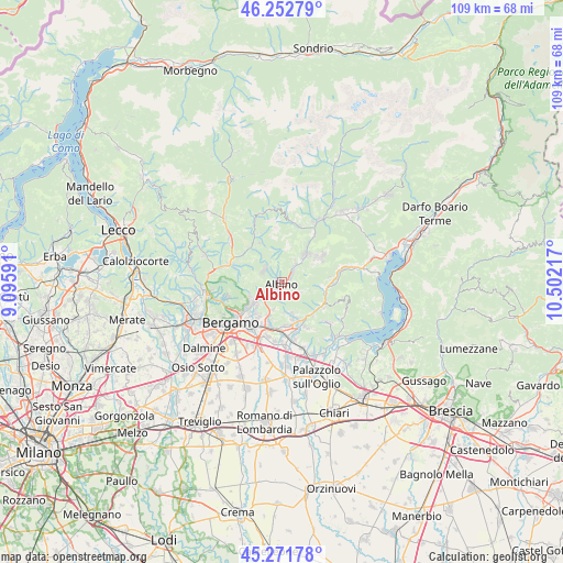
Albino GPS coordinates[2]
45° 45' 51.984" North, 9° 47' 56.544" East
| Map corner | latitude | longitude |
|---|---|---|
| Upper-left | 46.25279°, | 9.09591° |
| Center: | 45.76444°, | 9.79904° |
| Lower-right: | 45.27178°, | 10.50217° |
| Map W x H: | 109.1×109.1 km | = 67.8×67.8mi |
| max Lat: | 47.04031° ⇑15.8% North |
| Albino: | 45.76444° |
| min Lat: | ⇓84.2% South 35.50142° |
| min Long | Albino | max Long |
| 6.69888° | 9.79904° | 18.48682° |
| W 30.2%⇐ | ⇒69.8% E |
Elevation
Elevation of Albino is 375 m = 1230 ft, and this is 68.3 m = 224 ft above average elevation for this country.
| Max E: |
2085 m = 6841 ft | 31.8% |
| Albino | 375 m 1230 ft | |
| Avg. | 306.7 m = 1006 ft | |
Min E: |
-4 m = -13 ft | 68.2% |
See also: Italy elevation on elevation.city.
Geographical zone
Albino is located in North temperate zone (between Tropic of Cancer and the Arctic Circle). Distance of this North polar circle is 2312.6 km =1437 mi to North.| Distance of | km | miles | from Albino |
|---|---|---|---|
| North Pole | 4918.5 | 3056.2 | to North |
| Arctic Circle | 2312.6 | 1437 | to North |
| Tropic Cancer | 2482.6 | 1542.6 | to South |
| Equator | 5088.5 | 3161.8 | to South |


Nearby cities:
15 places around Albino: (largest is in red/bold)
• Abbazia
3.8 km =2.4 mi,  118°
118°
• Aviatico
4.3 km =2.7 mi,  329°
329°
• Casco
6.3 km =3.9 mi,  161°
161°
• Cenate Sopra
6 km =3.7 mi, 162°
• Cene
2.8 km =1.7 mi,  49°
49°
• Fiorano al Serio
5.2 km =3.2 mi,  40°
40°
• Gavarno Rinnovata
5.2 km =3.2 mi,  212°
212°
• Gavarno-Tribulina
5.6 km =3.5 mi,  199°
199°
• Gazzaniga
4 km =2.5 mi, 36°
• Masserini
4.9 km =3 mi,  30°
30°
• Nembro
3.7 km =2.3 mi,  232°
232°
• Orezzo
4.9 km =3 mi,  21°
21°
• Pradalunga
2.4 km =1.5 mi, 212°
• Selvino
4.3 km =2.7 mi,  302°
302°
• Vall'Alta
2.2 km =1.4 mi,  99°
99°
Sources, notices
• [Note1] Compared only with cities in Italy existing in our database
• [Src1] Map data: © OpenStreetMap contributors (CC-BY-SA)
• [Src2] Other city data from geonames.org with taken over terms of usage.
• [Src3] Geographical zone / Annual Mean Temperature by Robert A. Rohde @ Wikipedia
