Nembro geodata
Nembro (Lombardy) is a seat of a third-order administrative division; located in Italy in Europe/Rome (GMT+2) time zone. With population of 9,617 people, there are 984 cities with bigger population in this country. Compared to other cities in Italy, 83.3% of cities are located further ↓South; 70.1% of cities are located further →East and 62.5% of cities have lower elevation than Nembro. Note1


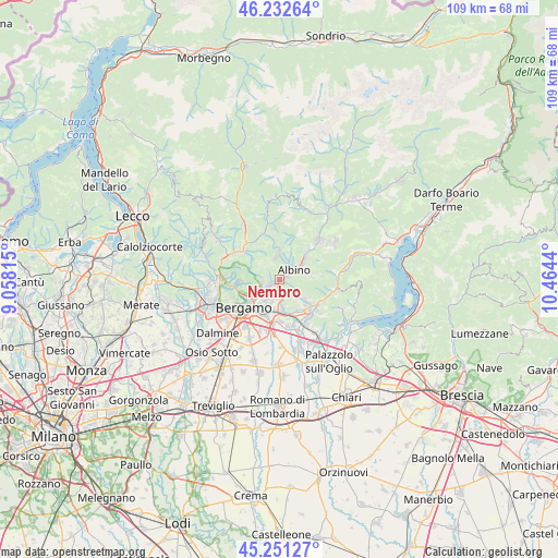
Nembro GPS coordinates[2]
45° 44' 38.796" North, 9° 45' 40.572" East
| Map corner | latitude | longitude |
|---|---|---|
| Upper-left | 46.23264°, | 9.05815° |
| Center: | 45.74411°, | 9.76127° |
| Lower-right: | 45.25127°, | 10.4644° |
| Map W x H: | 109.1×109.1 km | = 67.8×67.8mi |
| max Lat: | 47.04031° ⇑16.7% North |
| Nembro: | 45.74411° |
| min Lat: | ⇓83.3% South 35.50142° |
| min Long | Nembro | max Long |
| 6.69888° | 9.76127° | 18.48682° |
| W 29.9%⇐ | ⇒70.1% E |
Elevation
Elevation of Nembro is 319 m = 1047 ft, and this is 12.3 m = 40 ft above average elevation for this country.
| Max E: |
2085 m = 6841 ft | 37.5% |
| Nembro | 319 m 1047 ft | |
| Avg. | 306.7 m = 1006 ft | |
Min E: |
-4 m = -13 ft | 62.5% |
See also: Italy elevation on elevation.city.
Geographical zone
Nembro is located in North temperate zone (between Tropic of Cancer and the Arctic Circle). Distance of this North polar circle is 2314.9 km =1438.4 mi to North.| Distance of | km | miles | from Nembro |
|---|---|---|---|
| North Pole | 4920.8 | 3057.6 | to North |
| Arctic Circle | 2314.9 | 1438.4 | to North |
| Tropic Cancer | 2480.3 | 1541.2 | to South |
| Equator | 5086.3 | 3160.5 | to South |


Nearby cities:
15 places around Nembro: (largest is in red/bold)
• Albino
3.7 km =2.3 mi,  52°
52°
• Alzano Lombardo
2.8 km =1.7 mi,  253°
253°
• Cenate Sopra
5.9 km =3.7 mi,  126°
126°
• Gavarno Rinnovata
2.2 km =1.4 mi,  176°
176°
• Gavarno-Tribulina
3.2 km =2 mi,  160°
160°
• Negrone
3.8 km =2.4 mi, 183°
• Pedrengo
5.7 km =3.5 mi,  200°
200°
• Pradalunga
1.6 km =1 mi,  83°
83°
• Ranica
4.4 km =2.7 mi,  238°
238°
• Scanzo-Rosciate
4.2 km =2.6 mi,  208°
208°
• Selvino
4.6 km =2.9 mi,  351°
351°
• Torre Boldone
5.1 km =3.2 mi,  234°
234°
• Torre de' Roveri
5.2 km =3.2 mi, 178°
• Vall'Alta
5.4 km =3.4 mi,  69°
69°
• Villa di Serio
3.1 km =1.9 mi,  220°
220°
Sources, notices
• [Note1] Compared only with cities in Italy existing in our database
• [Src1] Map data: © OpenStreetMap contributors (CC-BY-SA)
• [Src2] Other city data from geonames.org with taken over terms of usage.
• [Src3] Geographical zone / Annual Mean Temperature by Robert A. Rohde @ Wikipedia
