Albano Sant'Alessandro geodata
Albano Sant'Alessandro (Lombardy) is a seat of a third-order administrative division; located in Italy in Europe/Rome (GMT+2) time zone. With population of 7,678 people, there are 1266 cities with bigger population in this country. Compared to other cities in Italy, 80.6% of cities are located further ↓South; 70.1% of cities are located further →East and 51.6% of cities have lower elevation than Albano Sant'Alessandro. Note1
Administrative division(s):
- Level 1: Lombardy
- Level 2: Provincia di Bergamo
- Level 3: Albano Sant'Alessandro
Current local time in Albano Sant'Alessandro:
07:59 PM, WednesdayDifference from your time zone: hours


Albano Sant'Alessandro GPS coordinates[2]
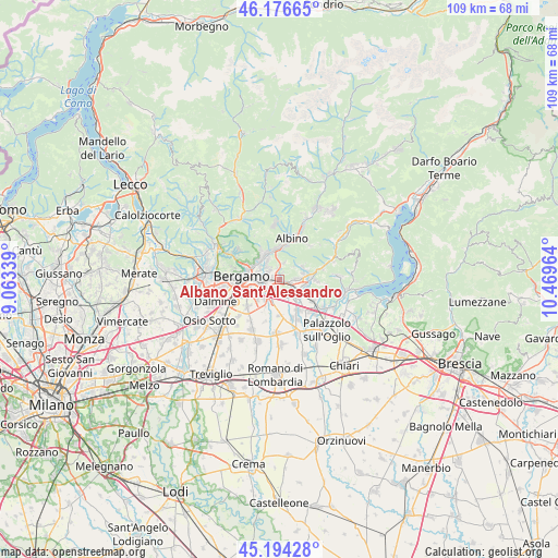
45° 41' 15.432" North, 9° 45' 59.436" East
| Map corner | latitude | longitude |
|---|---|---|
| Upper-left | 46.17665°, | 9.06339° |
| Center: | 45.68762°, | 9.76651° |
| Lower-right: | 45.19428°, | 10.46964° |
| Map W x H: | 109.2×109.2 km | = 67.9×67.9mi |
| max Lat: | 47.04031° ⇑19.4% North |
| Albano Sant'Alessandro: | 45.68762° |
| min Lat: | ⇓80.6% South 35.50142° |
| min Long | Albano Sant'Ale | max Long |
| 6.69888° | 9.76651° | 18.48682° |
| W 29.9%⇐ | ⇒70.1% E |
Elevation
Elevation of Albano Sant'Alessandro is 244 m = 801 ft, and this is 62.7 m = 206 ft below average elevation for this country.
| Max E: |
2085 m = 6841 ft | 48.4% |
| Avg. | 306.7 m = 1006 ft | |
| Albano Sant'Alessandro | 244 m = 801 ft | |
Min E: |
-4 m = -13 ft | 51.6% |
See also: Italy elevation on elevation.city.
Geographical zone
Albano Sant'Alessandro is located in North temperate zone (between Tropic of Cancer and the Arctic Circle). Distance of this North polar circle is 2321.2 km =1442.3 mi to North.| Distance of | km | miles | from Albano Sant'Alessandro |
|---|---|---|---|
| North Pole | 4927.1 | 3061.6 | to North |
| Arctic Circle | 2321.2 | 1442.3 | to North |
| Tropic Cancer | 2474.1 | 1537.3 | to South |
| Equator | 5080 | 3156.6 | to South |


Nearby cities:
15 places around Albano Sant'Alessandro: (largest is in red/bold)
• Bagnatica
3.2 km =2 mi,  159°
159°
• Brusaporto
1.9 km =1.2 mi,  194°
194°
• Costa di Mezzate
3.6 km =2.2 mi,  140°
140°
• Gavarno Rinnovata
4.1 km =2.5 mi,  356°
356°
• Gavarno-Tribulina
3.4 km =2.1 mi,  11°
11°
• Gorlago
4.6 km =2.9 mi,  108°
108°
• Gorle
4.4 km =2.7 mi,  290°
290°
• Montello
3.5 km =2.2 mi,  119°
119°
• Negrone
2.6 km =1.6 mi,  345°
345°
• Pedrengo
2.6 km =1.6 mi, 290°
• San Paolo d'Argon
2.8 km =1.7 mi,  88°
88°
• Scanzo-Rosciate
3.5 km =2.2 mi,  316°
316°
• Seriate
3.2 km =2 mi,  265°
265°
• Torre de' Roveri
1.1 km =0.7 mi, 346°
• Villa di Serio
4.6 km =2.9 mi,  328°
328°
Sources, notices
• [Note1] Compared only with cities in Italy existing in our database
• [Src1] Map data: © OpenStreetMap contributors (CC-BY-SA)
• [Src2] Other city data from geonames.org with taken over terms of usage.
• [Src3] Geographical zone / Annual Mean Temperature by Robert A. Rohde @ Wikipedia
