Scanzo-Rosciate geodata
Scanzo-Rosciate (Lombardy) is a seat of a third-order administrative division; located in Italy in Europe/Rome (GMT+2) time zone. With population of 6,207 people, there are 1577 cities with bigger population in this country. Compared to other cities in Italy, 81.7% of cities are located further ↓South; 70.4% of cities are located further →East and 56.6% of cities have lower elevation than Scanzo-Rosciate. Note1


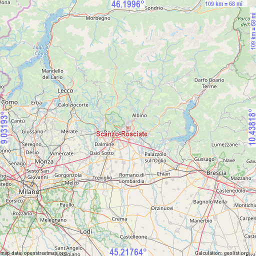
Scanzo-Rosciate GPS coordinates[2]
45° 42' 38.808" North, 9° 44' 6.18" East
| Map corner | latitude | longitude |
|---|---|---|
| Upper-left | 46.1996°, | 9.03193° |
| Center: | 45.71078°, | 9.73505° |
| Lower-right: | 45.21764°, | 10.43818° |
| Map W x H: | 109.2×109.2 km | = 67.9×67.9mi |
| max Lat: | 47.04031° ⇑18.3% North |
| Scanzo-Rosciate: | 45.71078° |
| min Lat: | ⇓81.7% South 35.50142° |
| min Long | Scanzo-Rosciate | max Long |
| 6.69888° | 9.73505° | 18.48682° |
| W 29.6%⇐ | ⇒70.4% E |
Elevation
Elevation of Scanzo-Rosciate is 276 m = 906 ft, and this is 30.7 m = 101 ft below average elevation for this country.
| Max E: |
2085 m = 6841 ft | 43.4% |
| Avg. | 306.7 m = 1006 ft | |
| Scanzo-Rosciate | 276 m = 906 ft | |
Min E: |
-4 m = -13 ft | 56.6% |
See also: Italy elevation on elevation.city.
Geographical zone
Scanzo-Rosciate is located in North temperate zone (between Tropic of Cancer and the Arctic Circle). Distance of this North polar circle is 2318.6 km =1440.7 mi to North.| Distance of | km | miles | from Scanzo-Rosciate |
|---|---|---|---|
| North Pole | 4924.5 | 3059.9 | to North |
| Arctic Circle | 2318.6 | 1440.7 | to North |
| Tropic Cancer | 2476.6 | 1538.9 | to South |
| Equator | 5082.6 | 3158.2 | to South |


Nearby cities:
15 places around Scanzo-Rosciate: (largest is in red/bold)
• Albano Sant'Alessandro
3.5 km =2.2 mi,  136°
136°
• Alzano Lombardo
3 km =1.9 mi,  346°
346°
• Brusaporto
4.8 km =3 mi,  155°
155°
• Gavarno Rinnovata
2.7 km =1.7 mi,  54°
54°
• Gavarno-Tribulina
3.2 km =2 mi,  76°
76°
• Gorle
2 km =1.2 mi,  237°
237°
• Negrone
1.8 km =1.1 mi,  91°
91°
• Nembro
4.2 km =2.6 mi,  28°
28°
• Orio al Serio
5.3 km =3.3 mi,  220°
220°
• Pedrengo
1.6 km =1 mi,  180°
180°
• Ranica
2.2 km =1.4 mi,  309°
309°
• Seriate
2.9 km =1.8 mi,  195°
195°
• Torre Boldone
2.2 km =1.4 mi,  288°
288°
• Torre de' Roveri
2.7 km =1.7 mi,  124°
124°
• Villa di Serio
1.3 km =0.8 mi,  0°
0°
Sources, notices
• [Note1] Compared only with cities in Italy existing in our database
• [Src1] Map data: © OpenStreetMap contributors (CC-BY-SA)
• [Src2] Other city data from geonames.org with taken over terms of usage.
• [Src3] Geographical zone / Annual Mean Temperature by Robert A. Rohde @ Wikipedia
