Gorle geodata
Gorle (Lombardy) is a seat of a third-order administrative division; located in Italy in Europe/Rome (GMT+2) time zone. With population of 6,441 people, there are 1518 cities with bigger population in this country. Compared to other cities in Italy, 81.2% of cities are located further ↓South; 70.6% of cities are located further →East and 55.7% of cities have lower elevation than Gorle. Note1


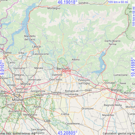
Gorle GPS coordinates[2]
45° 42' 4.572" North, 9° 42' 49.752" East
| Map corner | latitude | longitude |
|---|---|---|
| Upper-left | 46.19018°, | 9.0107° |
| Center: | 45.70127°, | 9.71382° |
| Lower-right: | 45.20805°, | 10.41695° |
| Map W x H: | 109.2×109.2 km | = 67.9×67.9mi |
| max Lat: | 47.04031° ⇑18.8% North |
| Gorle: | 45.70127° |
| min Lat: | ⇓81.2% South 35.50142° |
| min Long | Gorle | max Long |
| 6.69888° | 9.71382° | 18.48682° |
| W 29.4%⇐ | ⇒70.6% E |
Elevation
Elevation of Gorle is 270 m = 886 ft, and this is 36.7 m = 120 ft below average elevation for this country.
| Max E: |
2085 m = 6841 ft | 44.3% |
| Avg. | 306.7 m = 1006 ft | |
| Gorle | 270 m = 886 ft | |
Min E: |
-4 m = -13 ft | 55.7% |
See also: Italy elevation on elevation.city.
Geographical zone
Gorle is located in North temperate zone (between Tropic of Cancer and the Arctic Circle). Distance of this North polar circle is 2319.7 km =1441.4 mi to North.| Distance of | km | miles | from Gorle |
|---|---|---|---|
| North Pole | 4925.6 | 3060.6 | to North |
| Arctic Circle | 2319.7 | 1441.4 | to North |
| Tropic Cancer | 2475.6 | 1538.3 | to South |
| Equator | 5081.5 | 3157.5 | to South |


Nearby cities:
15 places around Gorle: (largest is in red/bold)
• Albano Sant'Alessandro
4.4 km =2.7 mi,  110°
110°
• Alzano Lombardo
4.1 km =2.5 mi,  13°
13°
• Bergamo
3.7 km =2.3 mi,  260°
260°
• Brusaporto
4.9 km =3 mi,  132°
132°
• Gavarno Rinnovata
4.6 km =2.9 mi,  55°
55°
• Grassobbio
5 km =3.1 mi,  169°
169°
• Negrone
3.6 km =2.2 mi,  73°
73°
• Orio al Serio
3.4 km =2.1 mi,  211°
211°
• Pedrengo
1.7 km =1.1 mi, 109°
• Ranica
2.4 km =1.5 mi,  359°
359°
• Scanzo-Rosciate
2 km =1.2 mi, 57°
• Seriate
2 km =1.2 mi,  154°
154°
• Torre Boldone
1.8 km =1.1 mi,  345°
345°
• Torre de' Roveri
3.9 km =2.4 mi,  96°
96°
• Villa di Serio
2.9 km =1.8 mi,  35°
35°
Sources, notices
• [Note1] Compared only with cities in Italy existing in our database
• [Src1] Map data: © OpenStreetMap contributors (CC-BY-SA)
• [Src2] Other city data from geonames.org with taken over terms of usage.
• [Src3] Geographical zone / Annual Mean Temperature by Robert A. Rohde @ Wikipedia
