Ruda geodata
Ruda (Friuli Venezia Giulia) is a seat of a third-order administrative division; located in Italy in Europe/Rome (GMT+2) time zone. With population of 1,399 people, there are 5361 cities with bigger population in this country. Compared to other cities in Italy, 87.4% of cities are located further ↓South; 72.4% of cities are located further ←West and 94.8% of cities have higher elevation than Ruda. Note1
Administrative division(s):
- Level 1: Friuli Venezia Giulia
- Level 2: Provincia di Udine
- Level 3: Ruda


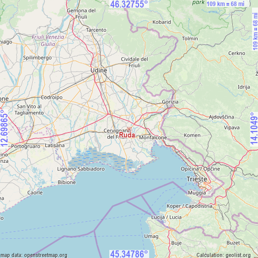
Ruda GPS coordinates[2]
45° 50' 23.496" North, 13° 24' 6.372" East
| Map corner | latitude | longitude |
|---|---|---|
| Upper-left | 46.32755°, | 12.69865° |
| Center: | 45.83986°, | 13.40177° |
| Lower-right: | 45.34786°, | 14.1049° |
| Map W x H: | 108.9×108.9 km | = 67.7×67.7mi |
| max Lat: | 47.04031° ⇑12.6% North |
| Ruda: | 45.83986° |
| min Lat: | ⇓87.4% South 35.50142° |
| min Long | Ruda | max Long |
| 6.69888° | 13.40177° | 18.48682° |
| W 72.4%⇐ | ⇒27.6% E |
Elevation
Elevation of Ruda is 9 m = 30 ft, and this is 297.7 m = 977 ft below average elevation for this country.
| Max E: |
2085 m = 6841 ft | 94.8% |
| Avg. | 306.7 m = 1006 ft | |
| Ruda | 9 m = 30 ft | |
Min E: |
-4 m = -13 ft | 5.2% |
See also: Italy elevation on elevation.city.
Geographical zone
Ruda is located in North temperate zone (between Tropic of Cancer and the Arctic Circle). Distance of this North polar circle is 2304.3 km =1431.8 mi to North.| Distance of | km | miles | from Ruda |
|---|---|---|---|
| North Pole | 4910.1 | 3051 | to North |
| Arctic Circle | 2304.3 | 1431.8 | to North |
| Tropic Cancer | 2491 | 1547.8 | to South |
| Equator | 5096.9 | 3167.1 | to South |


Nearby cities:
15 places around Ruda: (largest is in red/bold)
• Aiello del Friuli
4.9 km =3 mi,  318°
318°
• Begliano
5.4 km =3.4 mi,  114°
114°
• Campolongo al Torre
2.7 km =1.7 mi,  351°
351°
• Campolongo al Torre-Cavenzano
2.8 km =1.7 mi,  339°
339°
• Cervignano del Friuli
5.3 km =3.3 mi,  246°
246°
• Fiumicello
5.4 km =3.4 mi,  173°
173°
• Papariano
4 km =2.5 mi,  163°
163°
• Perteole
2 km =1.2 mi,  313°
313°
• Pieris
4.8 km =3 mi,  129°
129°
• Romans d'Isonzo
6.2 km =3.9 mi,  30°
30°
• San Pier d'Isonzo
5.1 km =3.2 mi,  84°
84°
• San Valentino
5.6 km =3.5 mi, 171°
• Turriaco
3.9 km =2.4 mi,  122°
122°
• Villa Vicentina
3 km =1.9 mi,  192°
192°
• Villesse
4.3 km =2.7 mi,  49°
49°
Sources, notices
• [Note1] Compared only with cities in Italy existing in our database
• [Src1] Map data: © OpenStreetMap contributors (CC-BY-SA)
• [Src2] Other city data from geonames.org with taken over terms of usage.
• [Src3] Geographical zone / Annual Mean Temperature by Robert A. Rohde @ Wikipedia
