Pieris geodata
Pieris (Friuli Venezia Giulia) is a seat of a third-order administrative division; located in Italy in Europe/Rome (GMT+2) time zone. With population of 3,140 people, there are 2932 cities with bigger population in this country. Compared to other cities in Italy, 86.3% of cities are located further ↓South; 73% of cities are located further ←West and 97.2% of cities have higher elevation than Pieris. Note1
Administrative division(s):
- Level 1: Friuli Venezia Giulia
- Level 2: Provincia di Gorizia
- Level 3: San Canzian d'Isonzo


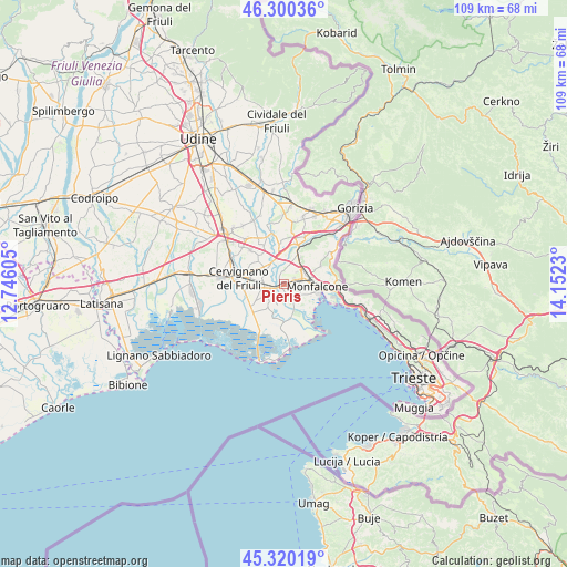
Pieris GPS coordinates[2]
45° 48' 44.748" North, 13° 26' 57.012" East
| Map corner | latitude | longitude |
|---|---|---|
| Upper-left | 46.30036°, | 12.74605° |
| Center: | 45.81243°, | 13.44917° |
| Lower-right: | 45.32019°, | 14.1523° |
| Map W x H: | 109×109 km | = 67.7×67.7mi |
| max Lat: | 47.04031° ⇑13.7% North |
| Pieris: | 45.81243° |
| min Lat: | ⇓86.3% South 35.50142° |
| min Long | Pieris | max Long |
| 6.69888° | 13.44917° | 18.48682° |
| W 73%⇐ | ⇒27% E |
Elevation
Elevation of Pieris is 5 m = 16 ft, and this is 301.7 m = 990 ft below average elevation for this country.
| Max E: |
2085 m = 6841 ft | 97.2% |
| Avg. | 306.7 m = 1006 ft | |
| Pieris | 5 m = 16 ft | |
Min E: |
-4 m = -13 ft | 2.8% |
See also: Italy elevation on elevation.city.
Geographical zone
Pieris is located in North temperate zone (between Tropic of Cancer and the Arctic Circle). Distance of this North polar circle is 2307.3 km =1433.7 mi to North.| Distance of | km | miles | from Pieris |
|---|---|---|---|
| North Pole | 4913.2 | 3052.9 | to North |
| Arctic Circle | 2307.3 | 1433.7 | to North |
| Tropic Cancer | 2487.9 | 1545.9 | to South |
| Equator | 5093.9 | 3165.2 | to South |


Nearby cities:
15 places around Pieris: (largest is in red/bold)
• Begliano
1.5 km =0.9 mi,  57°
57°
• Fiumicello
3.8 km =2.4 mi,  233°
233°
• Fogliano
6.4 km =4 mi,  23°
23°
• Papariano
2.7 km =1.7 mi,  253°
253°
• Polazzo
5.7 km =3.5 mi,  30°
30°
• Redipuglia
4.7 km =2.9 mi,  37°
37°
• Ronchi dei Legionari
4.6 km =2.9 mi,  68°
68°
• Ruda
4.8 km =3 mi,  309°
309°
• San Canzian d'Isonzo
2.1 km =1.3 mi,  141°
141°
• San Pier d'Isonzo
3.8 km =2.4 mi, 21°
• San Valentino
3.8 km =2.4 mi, 229°
• Staranzano
4.3 km =2.7 mi,  105°
105°
• Turriaco
1.1 km =0.7 mi,  336°
336°
• Villa Vicentina
4.3 km =2.7 mi,  271°
271°
• Villesse
5.9 km =3.7 mi,  355°
355°
Sources, notices
• [Note1] Compared only with cities in Italy existing in our database
• [Src1] Map data: © OpenStreetMap contributors (CC-BY-SA)
• [Src2] Other city data from geonames.org with taken over terms of usage.
• [Src3] Geographical zone / Annual Mean Temperature by Robert A. Rohde @ Wikipedia
