Palse geodata
Palse (Friuli Venezia Giulia) is a populated place; located in Italy in Europe/Rome (GMT+2) time zone. With population of 707 people, there are 8250 cities with bigger population in this country. Compared to other cities in Italy, 90.5% of cities are located further ↓South; 63.7% of cities are located further ←West and 89% of cities have higher elevation than Palse. Note1
Administrative division(s):
- Level 1: Friuli Venezia Giulia
- Level 2: Provincia di Pordenone
- Level 3: Porcia


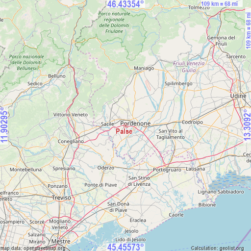
Palse GPS coordinates[2]
45° 56' 48.444" North, 12° 36' 21.852" East
| Map corner | latitude | longitude |
|---|---|---|
| Upper-left | 46.43354°, | 11.90295° |
| Center: | 45.94679°, | 12.60607° |
| Lower-right: | 45.45573°, | 13.3092° |
| Map W x H: | 108.7×108.7 km | = 67.5×67.5mi |
| max Lat: | 47.04031° ⇑9.5% North |
| Palse: | 45.94679° |
| min Lat: | ⇓90.5% South 35.50142° |
| min Long | Palse | max Long |
| 6.69888° | 12.60607° | 18.48682° |
| W 63.7%⇐ | ⇒36.3% E |
Elevation
Elevation of Palse is 20 m = 66 ft, and this is 286.7 m = 941 ft below average elevation for this country.
| Max E: |
2085 m = 6841 ft | 89% |
| Avg. | 306.7 m = 1006 ft | |
| Palse | 20 m = 66 ft | |
Min E: |
-4 m = -13 ft | 11% |
See also: Italy elevation on elevation.city.
Geographical zone
Palse is located in North temperate zone (between Tropic of Cancer and the Arctic Circle). Distance of this North polar circle is 2292.4 km =1424.4 mi to North.| Distance of | km | miles | from Palse |
|---|---|---|---|
| North Pole | 4898.3 | 3043.7 | to North |
| Arctic Circle | 2292.4 | 1424.4 | to North |
| Tropic Cancer | 2502.9 | 1555.2 | to South |
| Equator | 5108.8 | 3174.5 | to South |


Nearby cities:
15 places around Palse: (largest is in red/bold)
• Azzano Decimo
6.1 km =3.8 mi,  132°
132°
• Brugnera
7.2 km =4.5 mi,  223°
223°
• Ceolini
4.9 km =3 mi,  356°
356°
• Cinque Strade-Cimpello
8 km =5 mi,  114°
114°
• Musil
7.3 km =4.5 mi,  70°
70°
• Porcia
2 km =1.2 mi,  23°
23°
• Pordenone
4.4 km =2.7 mi,  75°
75°
• Prata di Pordenone
6 km =3.7 mi,  193°
193°
• Prata di Sotto
6.3 km =3.9 mi, 187°
• Roveredo in Piano
6.9 km =4.3 mi,  8°
8°
• San Giovanni di Livenza
7.6 km =4.7 mi,  247°
247°
• Tamai
3.6 km =2.2 mi,  226°
226°
• Vigonovo-Fontanafredda
6.6 km =4.1 mi,  316°
316°
• Villa D'Arco
7.5 km =4.7 mi,  38°
38°
• Visinale
5.7 km =3.5 mi,  174°
174°
Sources, notices
• [Note1] Compared only with cities in Italy existing in our database
• [Src1] Map data: © OpenStreetMap contributors (CC-BY-SA)
• [Src2] Other city data from geonames.org with taken over terms of usage.
• [Src3] Geographical zone / Annual Mean Temperature by Robert A. Rohde @ Wikipedia
