Cinque Strade-Cimpello geodata
Cinque Strade-Cimpello (Friuli Venezia Giulia) is a populated place; located in Italy in Europe/Rome (GMT+2) time zone. With population of 838 people, there are 7457 cities with bigger population in this country. Compared to other cities in Italy, 89.7% of cities are located further ↓South; 65% of cities are located further ←West and 91.1% of cities have higher elevation than Cinque Strade-Cimpello. Note1
Administrative division(s):
- Level 1: Friuli Venezia Giulia
- Level 2: Provincia di Pordenone
- Level 3: Fiume Veneto


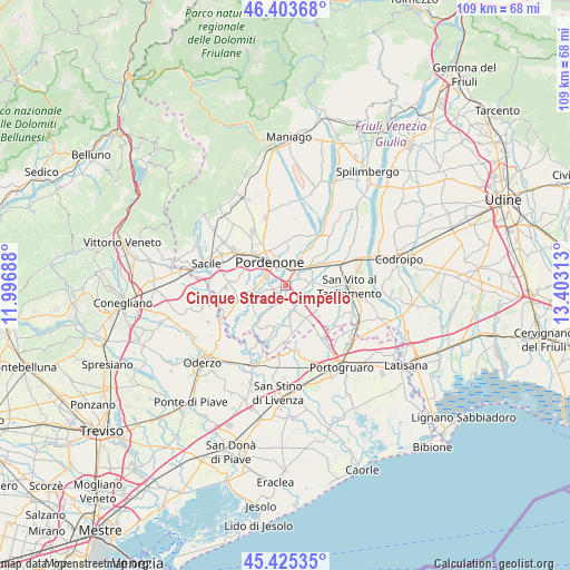
Cinque Strade-Cimpello GPS coordinates[2]
45° 55' 0.012" North, 12° 42' 0" East
| Map corner | latitude | longitude |
|---|---|---|
| Upper-left | 46.40368°, | 11.99688° |
| Center: | 45.91667°, | 12.7° |
| Lower-right: | 45.42535°, | 13.40313° |
| Map W x H: | 108.8×108.8 km | = 67.6×67.6mi |
| max Lat: | 47.04031° ⇑10.3% North |
| Cinque Strade-Cimpello: | 45.91667° |
| min Lat: | ⇓89.7% South 35.50142° |
| min Long | Cinque Strade-C | max Long |
| 6.69888° | 12.7° | 18.48682° |
| W 65%⇐ | ⇒35% E |
Elevation
Elevation of Cinque Strade-Cimpello is 16 m = 52 ft, and this is 290.7 m = 954 ft below average elevation for this country.
| Max E: |
2085 m = 6841 ft | 91.1% |
| Avg. | 306.7 m = 1006 ft | |
| Cinque Strade-Cimpello | 16 m = 52 ft | |
Min E: |
-4 m = -13 ft | 8.9% |
See also: Italy elevation on elevation.city.
Geographical zone
Cinque Strade-Cimpello is located in North temperate zone (between Tropic of Cancer and the Arctic Circle). Distance of this North polar circle is 2295.7 km =1426.5 mi to North.| Distance of | km | miles | from Cinque Strade-Cimpello |
|---|---|---|---|
| North Pole | 4901.6 | 3045.7 | to North |
| Arctic Circle | 2295.7 | 1426.5 | to North |
| Tropic Cancer | 2499.5 | 1553.1 | to South |
| Equator | 5105.5 | 3172.4 | to South |


Nearby cities:
15 places around Cinque Strade-Cimpello: (largest is in red/bold)
• Azzano Decimo
2.9 km =1.8 mi,  253°
253°
• Cecchini
8.3 km =5.2 mi,  226°
226°
• Chions
8 km =5 mi,  173°
173°
• Cordenons
7.4 km =4.6 mi,  0°
0°
• Fagnigola
7 km =4.3 mi,  189°
189°
• Fiume Veneto
3.2 km =2 mi,  65°
65°
• Musil
5.8 km =3.6 mi,  356°
356°
• Orcenico Inferiore
6.2 km =3.9 mi,  53°
53°
• Palse
8 km =5 mi,  294°
294°
• Porcia
8.3 km =5.2 mi,  308°
308°
• Pordenone
5.4 km =3.4 mi,  325°
325°
• Prata di Sotto
8.6 km =5.3 mi, 250°
• Villotta
7.3 km =4.5 mi,  144°
144°
• Visinale
7.1 km =4.4 mi, 251°
• Zoppola
7.6 km =4.7 mi,  43°
43°
Sources, notices
• [Note1] Compared only with cities in Italy existing in our database
• [Src1] Map data: © OpenStreetMap contributors (CC-BY-SA)
• [Src2] Other city data from geonames.org with taken over terms of usage.
• [Src3] Geographical zone / Annual Mean Temperature by Robert A. Rohde @ Wikipedia
