Piavon geodata
Piavon (Veneto) is a populated place; located in Italy in Europe/Rome (GMT+2) time zone. With population of 1,338 people, there are 5515 cities with bigger population in this country. Compared to other cities in Italy, 84.2% of cities are located further ↓South; 62.7% of cities are located further ←West and 97.2% of cities have higher elevation than Piavon. Note1


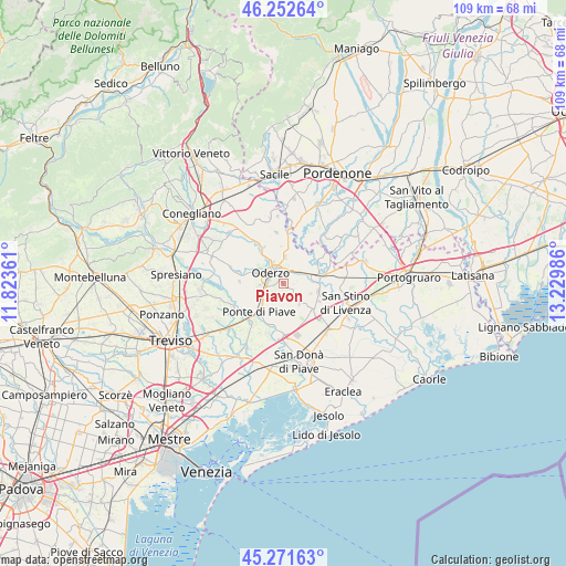
Piavon GPS coordinates[2]
45° 45' 51.444" North, 12° 31' 36.228" East
| Map corner | latitude | longitude |
|---|---|---|
| Upper-left | 46.25264°, | 11.82361° |
| Center: | 45.76429°, | 12.52673° |
| Lower-right: | 45.27163°, | 13.22986° |
| Map W x H: | 109.1×109.1 km | = 67.8×67.8mi |
| max Lat: | 47.04031° ⇑15.8% North |
| Piavon: | 45.76429° |
| min Lat: | ⇓84.2% South 35.50142° |
| min Long | Piavon | max Long |
| 6.69888° | 12.52673° | 18.48682° |
| W 62.7%⇐ | ⇒37.3% E |
Elevation
Elevation of Piavon is 5 m = 16 ft, and this is 301.7 m = 990 ft below average elevation for this country.
| Max E: |
2085 m = 6841 ft | 97.2% |
| Avg. | 306.7 m = 1006 ft | |
| Piavon | 5 m = 16 ft | |
Min E: |
-4 m = -13 ft | 2.8% |
See also: Italy elevation on elevation.city.
Geographical zone
Piavon is located in North temperate zone (between Tropic of Cancer and the Arctic Circle). Distance of this North polar circle is 2312.7 km =1437 mi to North.| Distance of | km | miles | from Piavon |
|---|---|---|---|
| North Pole | 4918.5 | 3056.2 | to North |
| Arctic Circle | 2312.7 | 1437 | to North |
| Tropic Cancer | 2482.6 | 1542.6 | to South |
| Equator | 5088.5 | 3161.8 | to South |


Nearby cities:
15 places around Piavon: (largest is in red/bold)
• Campo di Pietra
6.8 km =4.2 mi,  173°
173°
• Chiarano
5.2 km =3.2 mi,  137°
137°
• Faè
4.8 km =3 mi,  267°
267°
• Fossalta Maggiore
3.7 km =2.3 mi,  152°
152°
• Gorgo al Monticano
3.5 km =2.2 mi,  30°
30°
• Gorgo della Chiesa
3.8 km =2.4 mi,  47°
47°
• Levada
5.4 km =3.4 mi,  232°
232°
• Lutrano
6.9 km =4.3 mi,  323°
323°
• Mansuè
6.4 km =4 mi,  5°
5°
• Motta di Livenza
6.1 km =3.8 mi,  78°
78°
• Oderzo
3.1 km =1.9 mi,  306°
306°
• Ponte di Piave
7.1 km =4.4 mi, 225°
• Salgareda
7.2 km =4.5 mi,  204°
204°
• Talponada
7.3 km =4.5 mi, 202°
• Vigonovo di Sopra
6.8 km =4.2 mi,  218°
218°
Sources, notices
• [Note1] Compared only with cities in Italy existing in our database
• [Src1] Map data: © OpenStreetMap contributors (CC-BY-SA)
• [Src2] Other city data from geonames.org with taken over terms of usage.
• [Src3] Geographical zone / Annual Mean Temperature by Robert A. Rohde @ Wikipedia
