Vigonovo di Sopra geodata
Vigonovo di Sopra (Veneto) is a populated place; located in Italy in Europe/Rome (GMT+2) time zone. With population of 969 people, there are 6780 cities with bigger population in this country. Compared to other cities in Italy, 82% of cities are located further ↓South; 62% of cities are located further ←West and 94.8% of cities have higher elevation than Vigonovo di Sopra. Note1


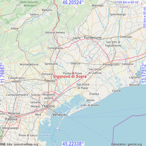
Vigonovo di Sopra GPS coordinates[2]
45° 42' 59.292" North, 12° 28' 19.164" East
| Map corner | latitude | longitude |
|---|---|---|
| Upper-left | 46.20524°, | 11.76887° |
| Center: | 45.71647°, | 12.47199° |
| Lower-right: | 45.22338°, | 13.17512° |
| Map W x H: | 109.2×109.2 km | = 67.9×67.9mi |
| max Lat: | 47.04031° ⇑18% North |
| Vigonovo di Sopra: | 45.71647° |
| min Lat: | ⇓82% South 35.50142° |
| min Long | Vigonovo di Sop | max Long |
| 6.69888° | 12.47199° | 18.48682° |
| W 62%⇐ | ⇒38% E |
Elevation
Elevation of Vigonovo di Sopra is 9 m = 30 ft, and this is 297.7 m = 977 ft below average elevation for this country.
| Max E: |
2085 m = 6841 ft | 94.8% |
| Avg. | 306.7 m = 1006 ft | |
| Vigonovo di Sopra | 9 m = 30 ft | |
Min E: |
-4 m = -13 ft | 5.2% |
See also: Italy elevation on elevation.city.
Geographical zone
Vigonovo di Sopra is located in North temperate zone (between Tropic of Cancer and the Arctic Circle). Distance of this North polar circle is 2318 km =1440.3 mi to North.| Distance of | km | miles | from Vigonovo di Sopra |
|---|---|---|---|
| North Pole | 4923.9 | 3059.6 | to North |
| Arctic Circle | 2318 | 1440.3 | to North |
| Tropic Cancer | 2477.3 | 1539.3 | to South |
| Equator | 5083.2 | 3158.6 | to South |


Nearby cities:
15 places around Vigonovo di Sopra: (largest is in red/bold)
• Bocca Callalta
2.6 km =1.6 mi,  240°
240°
• Campo di Pietra
5.2 km =3.2 mi,  105°
105°
• Campobernardo
5.9 km =3.7 mi,  119°
119°
• Fagarè
3.6 km =2.2 mi,  252°
252°
• Faè
5.1 km =3.2 mi,  353°
353°
• Fossalta Maggiore
6.3 km =3.9 mi,  71°
71°
• Levada
2 km =1.2 mi,  358°
358°
• Negrisia
3.4 km =2.1 mi,  304°
304°
• Ponte di Piave
0.8 km =0.5 mi,  289°
289°
• Roncadelle
6.6 km =4.1 mi,  313°
313°
• Rovarè
6.7 km =4.2 mi,  231°
231°
• Saletto-San Bartolomeo
6 km =3.7 mi,  280°
280°
• Salgareda
1.8 km =1.1 mi,  135°
135°
• Talponada
2 km =1.2 mi, 135°
• Zenson di Piave
4.3 km =2.7 mi,  161°
161°
Sources, notices
• [Note1] Compared only with cities in Italy existing in our database
• [Src1] Map data: © OpenStreetMap contributors (CC-BY-SA)
• [Src2] Other city data from geonames.org with taken over terms of usage.
• [Src3] Geographical zone / Annual Mean Temperature by Robert A. Rohde @ Wikipedia
