Mansuè geodata
Mansuè (Veneto) is a seat of a third-order administrative division; located in Italy in Europe/Rome (GMT+2) time zone. With population of 2,937 people, there are 3094 cities with bigger population in this country. Compared to other cities in Italy, 86.7% of cities are located further ↓South; 62.8% of cities are located further ←West and 93.6% of cities have higher elevation than Mansuè. Note1


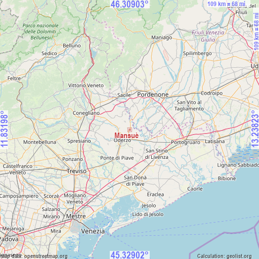
Mansuè GPS coordinates[2]
45° 49' 16.248" North, 12° 32' 6.36" East
| Map corner | latitude | longitude |
|---|---|---|
| Upper-left | 46.30903°, | 11.83198° |
| Center: | 45.82118°, | 12.5351° |
| Lower-right: | 45.32902°, | 13.23823° |
| Map W x H: | 109×109 km | = 67.7×67.7mi |
| max Lat: | 47.04031° ⇑13.3% North |
| Mansuè: | 45.82118° |
| min Lat: | ⇓86.7% South 35.50142° |
| min Long | Mansuè | max Long |
| 6.69888° | 12.5351° | 18.48682° |
| W 62.8%⇐ | ⇒37.2% E |
Elevation
Elevation of Mansuè is 11 m = 36 ft, and this is 295.7 m = 970 ft below average elevation for this country.
| Max E: |
2085 m = 6841 ft | 93.6% |
| Avg. | 306.7 m = 1006 ft | |
| Mansuè | 11 m = 36 ft | |
Min E: |
-4 m = -13 ft | 6.4% |
See also: Italy elevation on elevation.city.
Geographical zone
Mansuè is located in North temperate zone (between Tropic of Cancer and the Arctic Circle). Distance of this North polar circle is 2306.3 km =1433.1 mi to North.| Distance of | km | miles | from Mansuè |
|---|---|---|---|
| North Pole | 4912.2 | 3052.3 | to North |
| Arctic Circle | 2306.3 | 1433.1 | to North |
| Tropic Cancer | 2488.9 | 1546.5 | to South |
| Equator | 5094.8 | 3165.8 | to South |


Nearby cities:
15 places around Mansuè: (largest is in red/bold)
• Albina
7 km =4.3 mi,  346°
346°
• Fontanelle
5.5 km =3.4 mi,  284°
284°
• Gaiarine
7.8 km =4.8 mi,  327°
327°
• Ghirano
3.5 km =2.2 mi,  41°
41°
• Gorgo al Monticano
3.5 km =2.2 mi,  160°
160°
• Gorgo della Chiesa
4.3 km =2.7 mi,  150°
150°
• Lutrano
4.9 km =3 mi,  260°
260°
• Meduna di Livenza
7.2 km =4.5 mi,  93°
93°
• Motta di Livenza
7.4 km =4.6 mi,  133°
133°
• Oderzo
5.5 km =3.4 mi,  215°
215°
• Pasiano
7.8 km =4.8 mi,  66°
66°
• Piavon
6.4 km =4 mi,  185°
185°
• Portobuffolè
3.9 km =2.4 mi,  2°
2°
• Pozzo
6.8 km =4.2 mi,  60°
60°
• Puia-Villanova
5.4 km =3.4 mi,  31°
31°
Sources, notices
• [Note1] Compared only with cities in Italy existing in our database
• [Src1] Map data: © OpenStreetMap contributors (CC-BY-SA)
• [Src2] Other city data from geonames.org with taken over terms of usage.
• [Src3] Geographical zone / Annual Mean Temperature by Robert A. Rohde @ Wikipedia
