Guia geodata
Guia (Veneto) is a populated place; located in Italy in Europe/Rome (GMT+2) time zone. With population of 842 people, there are 7438 cities with bigger population in this country. Compared to other cities in Italy, 89.5% of cities are located further ↓South; 56.7% of cities are located further ←West and 56.6% of cities have lower elevation than Guia. Note1


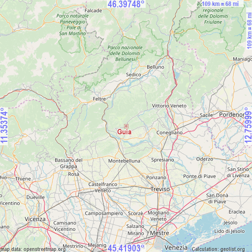
Guia GPS coordinates[2]
45° 54' 37.476" North, 12° 3' 24.696" East
| Map corner | latitude | longitude |
|---|---|---|
| Upper-left | 46.39748°, | 11.35374° |
| Center: | 45.91041°, | 12.05686° |
| Lower-right: | 45.41903°, | 12.75999° |
| Map W x H: | 108.8×108.8 km | = 67.6×67.6mi |
| max Lat: | 47.04031° ⇑10.5% North |
| Guia: | 45.91041° |
| min Lat: | ⇓89.5% South 35.50142° |
| min Long | Guia | max Long |
| 6.69888° | 12.05686° | 18.48682° |
| W 56.7%⇐ | ⇒43.3% E |
Elevation
Elevation of Guia is 276 m = 906 ft, and this is 30.7 m = 101 ft below average elevation for this country.
| Max E: |
2085 m = 6841 ft | 43.4% |
| Avg. | 306.7 m = 1006 ft | |
| Guia | 276 m = 906 ft | |
Min E: |
-4 m = -13 ft | 56.6% |
See also: Italy elevation on elevation.city.
Geographical zone
Guia is located in North temperate zone (between Tropic of Cancer and the Arctic Circle). Distance of this North polar circle is 2296.4 km =1426.9 mi to North.| Distance of | km | miles | from Guia |
|---|---|---|---|
| North Pole | 4902.3 | 3046.1 | to North |
| Arctic Circle | 2296.4 | 1426.9 | to North |
| Tropic Cancer | 2498.8 | 1552.7 | to South |
| Equator | 5104.8 | 3172 | to South |


Nearby cities:
15 places around Guia: (largest is in red/bold)
• Bigolino
5.8 km =3.6 mi,  212°
212°
• Col San Martino
4.7 km =2.9 mi,  103°
103°
• Covolo-Levada
8 km =5 mi, 210°
• Crocetta del Montello
8.4 km =5.2 mi,  192°
192°
• Farra di Soligo
5.3 km =3.3 mi, 96°
• Follina
6.8 km =4.2 mi,  45°
45°
• Miane
4.6 km =2.9 mi,  36°
36°
• Moriago della Battaglia
6 km =3.7 mi,  145°
145°
• Mosnigo
5.5 km =3.4 mi,  162°
162°
• Onigo
7.8 km =4.8 mi,  220°
220°
• Segusino
7.9 km =4.9 mi,  275°
275°
• Sernaglia della Battaglia
7.3 km =4.5 mi,  126°
126°
• Valdobbiadene
6 km =3.7 mi,  255°
255°
• Valmareno
8.4 km =5.2 mi, 42°
• Vidor
5 km =3.1 mi, 190°
Sources, notices
• [Note1] Compared only with cities in Italy existing in our database
• [Src1] Map data: © OpenStreetMap contributors (CC-BY-SA)
• [Src2] Other city data from geonames.org with taken over terms of usage.
• [Src3] Geographical zone / Annual Mean Temperature by Robert A. Rohde @ Wikipedia
