Valdobbiadene geodata
Valdobbiadene (Veneto) is a seat of a third-order administrative division; located in Italy in Europe/Rome (GMT+2) time zone. With population of 6,307 people, there are 1549 cities with bigger population in this country. Compared to other cities in Italy, 89.1% of cities are located further ↓South; 55.7% of cities are located further ←West and 51.8% of cities have higher elevation than Valdobbiadene. Note1


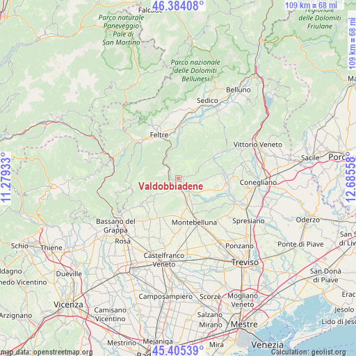
Valdobbiadene GPS coordinates[2]
45° 53' 48.804" North, 11° 58' 56.82" East
| Map corner | latitude | longitude |
|---|---|---|
| Upper-left | 46.38408°, | 11.27933° |
| Center: | 45.89689°, | 11.98245° |
| Lower-right: | 45.40539°, | 12.68558° |
| Map W x H: | 108.8×108.8 km | = 67.6×67.6mi |
| max Lat: | 47.04031° ⇑10.9% North |
| Valdobbiadene: | 45.89689° |
| min Lat: | ⇓89.1% South 35.50142° |
| min Long | Valdobbiadene | max Long |
| 6.69888° | 11.98245° | 18.48682° |
| W 55.7%⇐ | ⇒44.3% E |
Elevation
Elevation of Valdobbiadene is 223 m = 732 ft, and this is 83.7 m = 275 ft below average elevation for this country.
| Max E: |
2085 m = 6841 ft | 51.8% |
| Avg. | 306.7 m = 1006 ft | |
| Valdobbiadene | 223 m = 732 ft | |
Min E: |
-4 m = -13 ft | 48.2% |
See also: Italy elevation on elevation.city.
Geographical zone
Valdobbiadene is located in North temperate zone (between Tropic of Cancer and the Arctic Circle). Distance of this North polar circle is 2297.9 km =1427.8 mi to North.| Distance of | km | miles | from Valdobbiadene |
|---|---|---|---|
| North Pole | 4903.8 | 3047.1 | to North |
| Arctic Circle | 2297.9 | 1427.8 | to North |
| Tropic Cancer | 2497.3 | 1551.7 | to South |
| Equator | 5103.3 | 3171 | to South |


Nearby cities:
15 places around Valdobbiadene: (largest is in red/bold)
• Alano di Piave
5.8 km =3.6 mi,  280°
280°
• Bigolino
4.3 km =2.7 mi,  141°
141°
• Caniezza
8.1 km =5 mi,  232°
232°
• Cavaso del Tomba
7.6 km =4.7 mi,  238°
238°
• Colmirano
3.6 km =2.2 mi,  286°
286°
• Cornuda
7.5 km =4.7 mi,  165°
165°
• Covolo-Levada
5.7 km =3.5 mi,  161°
161°
• Crocetta del Montello
7.8 km =4.8 mi,  149°
149°
• Guia
6 km =3.7 mi,  75°
75°
• Onigo
4.5 km =2.8 mi, 171°
• Pederobba
3.5 km =2.2 mi, 226°
• Quero
4.8 km =3 mi,  304°
304°
• Segusino
3.1 km =1.9 mi,  317°
317°
• Vas
5.8 km =3.6 mi, 321°
• Vidor
5.9 km =3.7 mi,  124°
124°
Sources, notices
• [Note1] Compared only with cities in Italy existing in our database
• [Src1] Map data: © OpenStreetMap contributors (CC-BY-SA)
• [Src2] Other city data from geonames.org with taken over terms of usage.
• [Src3] Geographical zone / Annual Mean Temperature by Robert A. Rohde @ Wikipedia
