Bigolino geodata
Bigolino (Veneto) is a populated place; located in Italy in Europe/Rome (GMT+2) time zone. With population of 1,541 people, there are 5036 cities with bigger population in this country. Compared to other cities in Italy, 88.2% of cities are located further ↓South; 56.1% of cities are located further ←West and 58.7% of cities have higher elevation than Bigolino. Note1


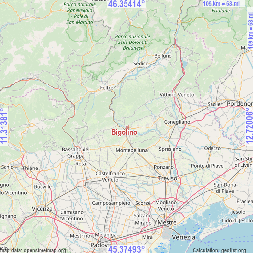
Bigolino GPS coordinates[2]
45° 52' 0.084" North, 12° 1' 0.948" East
| Map corner | latitude | longitude |
|---|---|---|
| Upper-left | 46.35414°, | 11.31381° |
| Center: | 45.86669°, | 12.01693° |
| Lower-right: | 45.37493°, | 12.72006° |
| Map W x H: | 108.9×108.9 km | = 67.7×67.7mi |
| max Lat: | 47.04031° ⇑11.8% North |
| Bigolino: | 45.86669° |
| min Lat: | ⇓88.2% South 35.50142° |
| min Long | Bigolino | max Long |
| 6.69888° | 12.01693° | 18.48682° |
| W 56.1%⇐ | ⇒43.9% E |
Elevation
Elevation of Bigolino is 174 m = 571 ft, and this is 132.7 m = 435 ft below average elevation for this country.
| Max E: |
2085 m = 6841 ft | 58.7% |
| Avg. | 306.7 m = 1006 ft | |
| Bigolino | 174 m = 571 ft | |
Min E: |
-4 m = -13 ft | 41.3% |
See also: Italy elevation on elevation.city.
Geographical zone
Bigolino is located in North temperate zone (between Tropic of Cancer and the Arctic Circle). Distance of this North polar circle is 2301.3 km =1430 mi to North.| Distance of | km | miles | from Bigolino |
|---|---|---|---|
| North Pole | 4907.2 | 3049.2 | to North |
| Arctic Circle | 2301.3 | 1430 | to North |
| Tropic Cancer | 2494 | 1549.7 | to South |
| Equator | 5099.9 | 3168.9 | to South |


Nearby cities:
15 places around Bigolino: (largest is in red/bold)
• Ciano
5.6 km =3.5 mi,  148°
148°
• Cornuda
4 km =2.5 mi,  192°
192°
• Covolo-Levada
2.2 km =1.4 mi,  204°
204°
• Crocetta del Montello
3.6 km =2.2 mi,  158°
158°
• Crocetta-Nogarè
4.5 km =2.8 mi,  166°
166°
• Guia
5.8 km =3.6 mi,  32°
32°
• Maser
7.3 km =4.5 mi,  206°
206°
• Moriago della Battaglia
6.5 km =4 mi,  90°
90°
• Mosnigo
4.8 km =3 mi, 94°
• Muliparte
6.2 km =3.9 mi, 203°
• Onigo
2.3 km =1.4 mi,  242°
242°
• Pederobba
5.3 km =3.3 mi,  280°
280°
• Segusino
7.3 km =4.5 mi,  319°
319°
• Valdobbiadene
4.3 km =2.7 mi, 321°
• Vidor
2.2 km =1.4 mi, 90°
Sources, notices
• [Note1] Compared only with cities in Italy existing in our database
• [Src1] Map data: © OpenStreetMap contributors (CC-BY-SA)
• [Src2] Other city data from geonames.org with taken over terms of usage.
• [Src3] Geographical zone / Annual Mean Temperature by Robert A. Rohde @ Wikipedia
