Dogaletto geodata
Dogaletto (Veneto) is a populated place; located in Italy in Europe/Rome (GMT+2) time zone. With population of 519 people, there are 9740 cities with bigger population in this country. Compared to other cities in Italy, 70.7% of cities are located further ↓South; 58.5% of cities are located further ←West and 99.7% of cities have higher elevation than Dogaletto. Note1


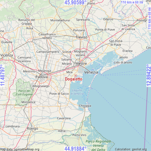
Dogaletto GPS coordinates[2]
45° 24' 52.452" North, 12° 11' 27.924" East
| Map corner | latitude | longitude |
|---|---|---|
| Upper-left | 45.90599°, | 11.48797° |
| Center: | 45.41457°, | 12.19109° |
| Lower-right: | 44.91884°, | 12.89422° |
| Map W x H: | 109.8×109.8 km | = 68.2×68.2mi |
| max Lat: | 47.04031° ⇑29.3% North |
| Dogaletto: | 45.41457° |
| min Lat: | ⇓70.7% South 35.50142° |
| min Long | Dogaletto | max Long |
| 6.69888° | 12.19109° | 18.48682° |
| W 58.5%⇐ | ⇒41.5% E |
Elevation
Elevation of Dogaletto is 0 m = 0 ft, and this is 306.7 m = 1006 ft below average elevation for this country.
| Max E: |
2085 m = 6841 ft | 99.7% |
| Avg. | 306.7 m = 1006 ft | |
| Dogaletto | 0 m = 0 ft | |
Min E: |
-4 m = -13 ft | 0.3% |
See also: Italy elevation on elevation.city.
Geographical zone
Dogaletto is located in North temperate zone (between Tropic of Cancer and the Arctic Circle). Distance of this North polar circle is 2351.5 km =1461.2 mi to North.| Distance of | km | miles | from Dogaletto |
|---|---|---|---|
| North Pole | 4957.4 | 3080.4 | to North |
| Arctic Circle | 2351.5 | 1461.2 | to North |
| Tropic Cancer | 2443.7 | 1518.4 | to South |
| Equator | 5049.6 | 3137.7 | to South |


Nearby cities:
15 places around Dogaletto: (largest is in red/bold)
• Ca' Sabbioni
4.7 km =2.9 mi,  353°
353°
• Campagna Lupia
10 km =6.2 mi,  227°
227°
• Camponogara
9.1 km =5.7 mi,  244°
244°
• Case Dosa
9.6 km =6 mi,  4°
4°
• Cazzago-Ex Polo
9.6 km =6 mi,  288°
288°
• Dolo
8.4 km =5.2 mi,  278°
278°
• Fornase
7.2 km =4.5 mi,  342°
342°
• Fossa
9.8 km =6.1 mi,  333°
333°
• Lughetto
5.7 km =3.5 mi, 237°
• Marano
7.9 km =4.9 mi,  313°
313°
• Mestre
9.6 km =6 mi,  26°
26°
• Mira Taglio
5.3 km =3.3 mi, 294°
• Sambruson
6.9 km =4.3 mi,  266°
266°
• Spinea-Orgnano
9 km =5.6 mi, 341°
• Vetrego
8.4 km =5.2 mi,  303°
303°
Sources, notices
• [Note1] Compared only with cities in Italy existing in our database
• [Src1] Map data: © OpenStreetMap contributors (CC-BY-SA)
• [Src2] Other city data from geonames.org with taken over terms of usage.
• [Src3] Geographical zone / Annual Mean Temperature by Robert A. Rohde @ Wikipedia
