Cavrie geodata
Cavrie (Veneto) is a populated place; located in Italy in Europe/Rome (GMT+2) time zone. With population of 852 people, there are 7395 cities with bigger population in this country. Compared to other cities in Italy, 81.3% of cities are located further ↓South; 60.9% of cities are located further ←West and 90.6% of cities have higher elevation than Cavrie. Note1
Administrative division(s):
- Level 1: Veneto
- Level 2: Provincia di Treviso
- Level 3: San Biagio di Callalta


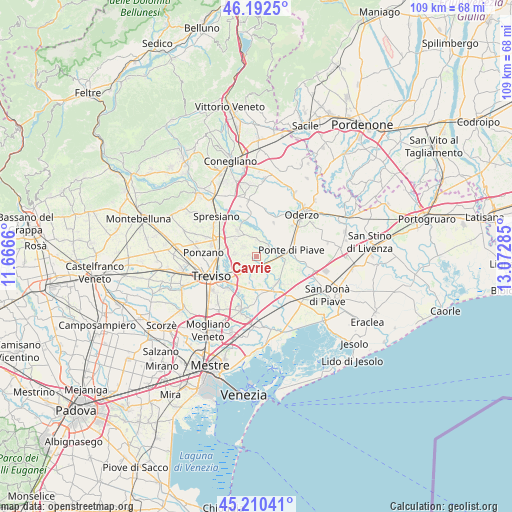
Cavrie GPS coordinates[2]
45° 42' 12.996" North, 12° 22' 10.992" East
| Map corner | latitude | longitude |
|---|---|---|
| Upper-left | 46.1925°, | 11.6666° |
| Center: | 45.70361°, | 12.36972° |
| Lower-right: | 45.21041°, | 13.07285° |
| Map W x H: | 109.2×109.2 km | = 67.9×67.9mi |
| max Lat: | 47.04031° ⇑18.7% North |
| Cavrie: | 45.70361° |
| min Lat: | ⇓81.3% South 35.50142° |
| min Long | Cavrie | max Long |
| 6.69888° | 12.36972° | 18.48682° |
| W 60.9%⇐ | ⇒39.1% E |
Elevation
Elevation of Cavrie is 17 m = 56 ft, and this is 289.7 m = 950 ft below average elevation for this country.
| Max E: |
2085 m = 6841 ft | 90.6% |
| Avg. | 306.7 m = 1006 ft | |
| Cavrie | 17 m = 56 ft | |
Min E: |
-4 m = -13 ft | 9.4% |
See also: Italy elevation on elevation.city.
Geographical zone
Cavrie is located in North temperate zone (between Tropic of Cancer and the Arctic Circle). Distance of this North polar circle is 2319.4 km =1441.2 mi to North.| Distance of | km | miles | from Cavrie |
|---|---|---|---|
| North Pole | 4925.3 | 3060.4 | to North |
| Arctic Circle | 2319.4 | 1441.2 | to North |
| Tropic Cancer | 2475.8 | 1538.4 | to South |
| Equator | 5081.8 | 3157.7 | to South |


Nearby cities:
15 places around Cavrie: (largest is in red/bold)
• Bocca Callalta
5.7 km =3.5 mi,  88°
88°
• Breda
3.7 km =2.3 mi,  304°
304°
• Candelù
3.5 km =2.2 mi,  3°
3°
• Fagarè
4.5 km =2.8 mi, 85°
• Mignagola
4.1 km =2.5 mi,  246°
246°
• Negrisia
6.1 km =3.8 mi,  57°
57°
• Pero
1.7 km =1.1 mi,  280°
280°
• Pezzan
6.1 km =3.8 mi,  263°
263°
• Rovarè
3.8 km =2.4 mi,  136°
136°
• Saletto-San Bartolomeo
3.2 km =2 mi,  38°
38°
• San Biagio di Callalta
2.3 km =1.4 mi,  165°
165°
• San Floriano-Olmi
4.5 km =2.8 mi,  222°
222°
• San Giacomo di Musestrelle
2.8 km =1.7 mi,  274°
274°
• Vacil
4.8 km =3 mi, 278°
• Varago
5.9 km =3.7 mi,  309°
309°
Sources, notices
• [Note1] Compared only with cities in Italy existing in our database
• [Src1] Map data: © OpenStreetMap contributors (CC-BY-SA)
• [Src2] Other city data from geonames.org with taken over terms of usage.
• [Src3] Geographical zone / Annual Mean Temperature by Robert A. Rohde @ Wikipedia
