Perlo geodata
Perlo (Piedmont) is a seat of a third-order administrative division; located in Italy in Europe/Rome (GMT+2) time zone. With population of 130 people, there are 11351 cities with bigger population in this country. Compared to other cities in Italy, 51.5% of cities are located further ↑North; 92.5% of cities are located further →East and 91% of cities have lower elevation than Perlo. Note1


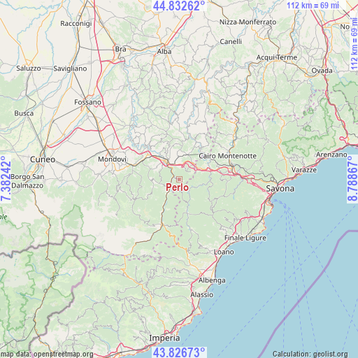
Perlo GPS coordinates[2]
44° 19' 54.588" North, 8° 5' 7.944" East
| Map corner | latitude | longitude |
|---|---|---|
| Upper-left | 44.83262°, | 7.38242° |
| Center: | 44.33183°, | 8.08554° |
| Lower-right: | 43.82673°, | 8.78867° |
| Map W x H: | 111.8×111.8 km | = 69.5×69.5mi |
| max Lat: | 47.04031° ⇑51.5% North |
| Perlo: | 44.33183° |
| min Lat: | ⇓48.5% South 35.50142° |
| min Long | Perlo | max Long |
| 6.69888° | 8.08554° | 18.48682° |
| W 7.5%⇐ | ⇒92.5% E |
Elevation
Elevation of Perlo is 745 m = 2444 ft, and this is 438.3 m = 1438 ft above average elevation for this country.
| Max E: |
2085 m = 6841 ft | 9% |
| Perlo | 745 m 2444 ft | |
| Avg. | 306.7 m = 1006 ft | |
Min E: |
-4 m = -13 ft | 91% |
See also: Italy elevation on elevation.city.
Geographical zone
Perlo is located in North temperate zone (between Tropic of Cancer and the Arctic Circle). Distance of this Northern Tropic circle is 2323.3 km =1443.6 mi to South.| Distance of | km | miles | from Perlo |
|---|---|---|---|
| North Pole | 5077.8 | 3155.2 | to North |
| Arctic Circle | 2471.9 | 1536 | to North |
| Tropic Cancer | 2323.3 | 1443.6 | to South |
| Equator | 4929.2 | 3062.9 | to South |


Nearby cities:
15 places around Perlo: (largest is in red/bold)
• Bagnasco
4.4 km =2.7 mi,  226°
226°
• Battifollo
6.1 km =3.8 mi,  257°
257°
• Castelnuovo di Ceva
4.2 km =2.6 mi,  54°
54°
• Ceva
7.5 km =4.7 mi,  322°
322°
• Lisio
8.9 km =5.5 mi,  252°
252°
• Massimino
3.8 km =2.4 mi,  197°
197°
• Montezemolo
6.7 km =4.2 mi,  41°
41°
• Murialdo
6.8 km =4.2 mi,  104°
104°
• Nucetto
2.2 km =1.4 mi,  292°
292°
• Piano
6.6 km =4.1 mi, 104°
• Priero
5 km =3.1 mi,  7°
7°
• Sale San Giovanni
7.5 km =4.7 mi,  355°
355°
• Sale delle Langhe
7.1 km =4.4 mi, 356°
• Scagnello
7.9 km =4.9 mi,  271°
271°
• Valzemola
7.9 km =4.9 mi,  63°
63°
Sources, notices
• [Note1] Compared only with cities in Italy existing in our database
• [Src1] Map data: © OpenStreetMap contributors (CC-BY-SA)
• [Src2] Other city data from geonames.org with taken over terms of usage.
• [Src3] Geographical zone / Annual Mean Temperature by Robert A. Rohde @ Wikipedia
