Bagnasco geodata
Bagnasco (Piedmont) is a seat of a third-order administrative division; located in Italy in Europe/Rome (GMT+2) time zone. With population of 936 people, there are 6952 cities with bigger population in this country. Compared to other cities in Italy, 51.9% of cities are located further ↑North; 93% of cities are located further →East and 77.7% of cities have lower elevation than Bagnasco. Note1


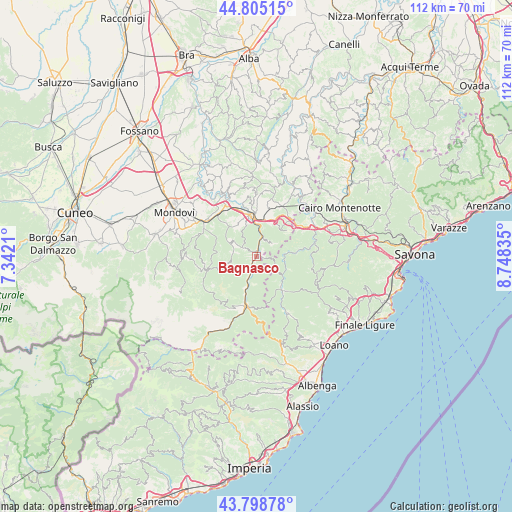
Bagnasco GPS coordinates[2]
44° 18' 14.832" North, 8° 2' 42.792" East
| Map corner | latitude | longitude |
|---|---|---|
| Upper-left | 44.80515°, | 7.3421° |
| Center: | 44.30412°, | 8.04522° |
| Lower-right: | 43.79878°, | 8.74835° |
| Map W x H: | 111.9×111.9 km | = 69.5×69.5mi |
| max Lat: | 47.04031° ⇑51.9% North |
| Bagnasco: | 44.30412° |
| min Lat: | ⇓48.1% South 35.50142° |
| min Long | Bagnasco | max Long |
| 6.69888° | 8.04522° | 18.48682° |
| W 7%⇐ | ⇒93% E |
Elevation
Elevation of Bagnasco is 488 m = 1601 ft, and this is 181.3 m = 595 ft above average elevation for this country.
| Max E: |
2085 m = 6841 ft | 22.3% |
| Bagnasco | 488 m 1601 ft | |
| Avg. | 306.7 m = 1006 ft | |
Min E: |
-4 m = -13 ft | 77.7% |
See also: Italy elevation on elevation.city.
Geographical zone
Bagnasco is located in North temperate zone (between Tropic of Cancer and the Arctic Circle). Distance of this Northern Tropic circle is 2320.2 km =1441.7 mi to South.| Distance of | km | miles | from Bagnasco |
|---|---|---|---|
| North Pole | 5080.9 | 3157.1 | to North |
| Arctic Circle | 2475 | 1537.9 | to North |
| Tropic Cancer | 2320.2 | 1441.7 | to South |
| Equator | 4926.2 | 3061 | to South |


Nearby cities:
15 places around Bagnasco: (largest is in red/bold)
• Battifollo
3.2 km =2 mi,  302°
302°
• Calizzano
9.5 km =5.9 mi,  142°
142°
• Castelnuovo di Ceva
8.6 km =5.3 mi,  50°
50°
• Ceva
9.1 km =5.7 mi,  351°
351°
• Lisio
5.3 km =3.3 mi,  273°
273°
• Massimino
2.1 km =1.3 mi,  103°
103°
• Mombasiglio
9.3 km =5.8 mi,  318°
318°
• Monasterolo Casotto
8.5 km =5.3 mi,  288°
288°
• Nucetto
4.1 km =2.5 mi,  16°
16°
• Perlo
4.4 km =2.7 mi, 46°
• Piano
9.7 km =6 mi,  81°
81°
• Priero
8.9 km =5.5 mi,  25°
25°
• Priola
6.9 km =4.3 mi,  195°
195°
• Scagnello
5.7 km =3.5 mi, 304°
• Viola
6.6 km =4.1 mi,  256°
256°
Sources, notices
• [Note1] Compared only with cities in Italy existing in our database
• [Src1] Map data: © OpenStreetMap contributors (CC-BY-SA)
• [Src2] Other city data from geonames.org with taken over terms of usage.
• [Src3] Geographical zone / Annual Mean Temperature by Robert A. Rohde @ Wikipedia
