Montezemolo geodata
Montezemolo (Piedmont) is a seat of a third-order administrative division; located in Italy in Europe/Rome (GMT+2) time zone. With population of 305 people, there are 10655 cities with bigger population in this country. Compared to other cities in Italy, 50.8% of cities are located further ↑North; 91.7% of cities are located further →East and 90.6% of cities have lower elevation than Montezemolo. Note1


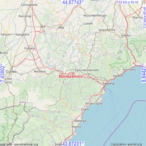
Montezemolo GPS coordinates[2]
44° 22' 37.308" North, 8° 8' 28.104" East
| Map corner | latitude | longitude |
|---|---|---|
| Upper-left | 44.87743°, | 7.43802° |
| Center: | 44.37703°, | 8.14114° |
| Lower-right: | 43.87231°, | 8.84427° |
| Map W x H: | 111.8×111.8 km | = 69.5×69.5mi |
| max Lat: | 47.04031° ⇑50.8% North |
| Montezemolo: | 44.37703° |
| min Lat: | ⇓49.2% South 35.50142° |
| min Long | Montezemolo | max Long |
| 6.69888° | 8.14114° | 18.48682° |
| W 8.3%⇐ | ⇒91.7% E |
Elevation
Elevation of Montezemolo is 734 m = 2408 ft, and this is 427.3 m = 1402 ft above average elevation for this country.
| Max E: |
2085 m = 6841 ft | 9.4% |
| Montezemolo | 734 m 2408 ft | |
| Avg. | 306.7 m = 1006 ft | |
Min E: |
-4 m = -13 ft | 90.6% |
See also: Italy elevation on elevation.city.
Geographical zone
Montezemolo is located in North temperate zone (between Tropic of Cancer and the Arctic Circle). Distance of this Northern Tropic circle is 2328.3 km =1446.7 mi to South.| Distance of | km | miles | from Montezemolo |
|---|---|---|---|
| North Pole | 5072.8 | 3152.1 | to North |
| Arctic Circle | 2466.9 | 1532.9 | to North |
| Tropic Cancer | 2328.3 | 1446.7 | to South |
| Equator | 4934.3 | 3066 | to South |


Nearby cities:
15 places around Montezemolo: (largest is in red/bold)
• Bormida-Genepro
4.9 km =3 mi,  72°
72°
• Camerana
5.2 km =3.2 mi,  0°
0°
• Castelnuovo di Ceva
2.8 km =1.7 mi,  200°
200°
• Cengio Alto
4.6 km =2.9 mi,  79°
79°
• Cosseria
7.5 km =4.7 mi,  97°
97°
• Millesimo
5.1 km =3.2 mi, 102°
• Murialdo
7 km =4.3 mi,  162°
162°
• Perlo
6.7 km =4.2 mi,  221°
221°
• Piano
7 km =4.3 mi, 163°
• Priero
3.8 km =2.4 mi,  268°
268°
• Roccavignale
4.3 km =2.7 mi,  114°
114°
• Sale San Giovanni
5.6 km =3.5 mi,  296°
296°
• Sale delle Langhe
5.3 km =3.3 mi,  292°
292°
• Saliceto
4.6 km =2.9 mi,  28°
28°
• Valzemola
3 km =1.9 mi,  119°
119°
Sources, notices
• [Note1] Compared only with cities in Italy existing in our database
• [Src1] Map data: © OpenStreetMap contributors (CC-BY-SA)
• [Src2] Other city data from geonames.org with taken over terms of usage.
• [Src3] Geographical zone / Annual Mean Temperature by Robert A. Rohde @ Wikipedia
