Giusvalla geodata
Giusvalla (Liguria) is a seat of a third-order administrative division; located in Italy in Europe/Rome (GMT+2) time zone. With population of 98 people, there are 11449 cities with bigger population in this country. Compared to other cities in Italy, 50.3% of cities are located further ↓South; 89.2% of cities are located further →East and 75.2% of cities have lower elevation than Giusvalla. Note1


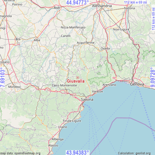
Giusvalla GPS coordinates[2]
44° 26' 52.584" North, 8° 23' 38.94" East
| Map corner | latitude | longitude |
|---|---|---|
| Upper-left | 44.94773°, | 7.69103° |
| Center: | 44.44794°, | 8.39415° |
| Lower-right: | 43.94383°, | 9.09728° |
| Map W x H: | 111.6×111.6 km | = 69.3×69.3mi |
| max Lat: | 47.04031° ⇑49.7% North |
| Giusvalla: | 44.44794° |
| min Lat: | ⇓50.3% South 35.50142° |
| min Long | Giusvalla | max Long |
| 6.69888° | 8.39415° | 18.48682° |
| W 10.8%⇐ | ⇒89.2% E |
Elevation
Elevation of Giusvalla is 454 m = 1490 ft, and this is 147.3 m = 483 ft above average elevation for this country.
| Max E: |
2085 m = 6841 ft | 24.8% |
| Giusvalla | 454 m 1490 ft | |
| Avg. | 306.7 m = 1006 ft | |
Min E: |
-4 m = -13 ft | 75.2% |
See also: Italy elevation on elevation.city.
Geographical zone
Giusvalla is located in North temperate zone (between Tropic of Cancer and the Arctic Circle). Distance of this Northern Tropic circle is 2336.2 km =1451.6 mi to South.| Distance of | km | miles | from Giusvalla |
|---|---|---|---|
| North Pole | 5064.9 | 3147.2 | to North |
| Arctic Circle | 2459 | 1528 | to North |
| Tropic Cancer | 2336.2 | 1451.6 | to South |
| Equator | 4942.1 | 3070.9 | to South |


Nearby cities:
15 places around Giusvalla: (largest is in red/bold)
• Cairo Montenotte
10.8 km =6.7 mi,  238°
238°
• Dego
6.9 km =4.3 mi,  266°
266°
• Ellera
10.9 km =6.8 mi,  148°
148°
• Ferrania
11.5 km =7.1 mi,  211°
211°
• Merana
11 km =6.8 mi,  316°
316°
• Mioglia
5.2 km =3.2 mi,  18°
18°
• Molino-Pera
8.1 km =5 mi,  303°
303°
• Osteria dei Cacciatori-Stella
6.4 km =4 mi,  107°
107°
• Pareto
7.7 km =4.8 mi,  352°
352°
• Piana Crixia
8 km =5 mi, 301°
• Pontinvrea
3.4 km =2.1 mi,  101°
101°
• Rocchetta Cairo
7.8 km =4.8 mi,  254°
254°
• San Giovanni
10.2 km =6.3 mi,  126°
126°
• San Martino
11.5 km =7.1 mi,  123°
123°
• Sassello
8.7 km =5.4 mi,  65°
65°
Sources, notices
• [Note1] Compared only with cities in Italy existing in our database
• [Src1] Map data: © OpenStreetMap contributors (CC-BY-SA)
• [Src2] Other city data from geonames.org with taken over terms of usage.
• [Src3] Geographical zone / Annual Mean Temperature by Robert A. Rohde @ Wikipedia
