Sassello geodata
Sassello (Liguria) is a seat of a third-order administrative division; located in Italy in Europe/Rome (GMT+2) time zone. With population of 1,115 people, there are 6233 cities with bigger population in this country. Compared to other cities in Italy, 50.7% of cities are located further ↓South; 88% of cities are located further →East and 69.6% of cities have lower elevation than Sassello. Note1


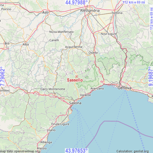
Sassello GPS coordinates[2]
44° 28' 49.296" North, 8° 29' 37.5" East
| Map corner | latitude | longitude |
|---|---|---|
| Upper-left | 44.97988°, | 7.79062° |
| Center: | 44.48036°, | 8.49375° |
| Lower-right: | 43.97653°, | 9.19687° |
| Map W x H: | 111.6×111.6 km | = 69.3×69.3mi |
| max Lat: | 47.04031° ⇑49.3% North |
| Sassello: | 44.48036° |
| min Lat: | ⇓50.7% South 35.50142° |
| min Long | Sassello | max Long |
| 6.69888° | 8.49375° | 18.48682° |
| W 12%⇐ | ⇒88% E |
Elevation
Elevation of Sassello is 390 m = 1280 ft, and this is 83.3 m = 273 ft above average elevation for this country.
| Max E: |
2085 m = 6841 ft | 30.4% |
| Sassello | 390 m 1280 ft | |
| Avg. | 306.7 m = 1006 ft | |
Min E: |
-4 m = -13 ft | 69.6% |
See also: Italy elevation on elevation.city.
Geographical zone
Sassello is located in North temperate zone (between Tropic of Cancer and the Arctic Circle). Distance of this Northern Tropic circle is 2339.8 km =1453.9 mi to South.| Distance of | km | miles | from Sassello |
|---|---|---|---|
| North Pole | 5061.3 | 3144.9 | to North |
| Arctic Circle | 2455.4 | 1525.7 | to North |
| Tropic Cancer | 2339.8 | 1453.9 | to South |
| Equator | 4945.8 | 3073.2 | to South |


Nearby cities:
15 places around Sassello: (largest is in red/bold)
• Casavecchia
11.4 km =7.1 mi,  62°
62°
• Giusvalla
8.7 km =5.4 mi,  245°
245°
• Malvicino
10.9 km =6.8 mi,  323°
323°
• Mioglia
6.4 km =4 mi,  281°
281°
• Osteria dei Cacciatori-Stella
5.8 km =3.6 mi,  197°
197°
• Pareto
9.7 km =6 mi,  294°
294°
• Pero
11.2 km =7 mi,  157°
157°
• Pontinvrea
6.2 km =3.9 mi,  226°
226°
• Ponzone
12.3 km =7.6 mi,  347°
347°
• San Giovanni
9.6 km =6 mi,  178°
178°
• San Martino
10.1 km =6.3 mi,  170°
170°
• San Pietro d'Olba
7.6 km =4.7 mi,  83°
83°
• Sciarborasca
13 km =8.1 mi,  132°
132°
• Tiglieto
11 km =6.8 mi, 64°
• Urbe
7.4 km =4.6 mi, 84°
Sources, notices
• [Note1] Compared only with cities in Italy existing in our database
• [Src1] Map data: © OpenStreetMap contributors (CC-BY-SA)
• [Src2] Other city data from geonames.org with taken over terms of usage.
• [Src3] Geographical zone / Annual Mean Temperature by Robert A. Rohde @ Wikipedia
