Alassio geodata
Alassio (Liguria) is a seat of a third-order administrative division; located in Italy in Europe/Rome (GMT+2) time zone. With population of 10,623 people, there are 892 cities with bigger population in this country. Compared to other cities in Italy, 54.6% of cities are located further ↑North; 91.5% of cities are located further →East and 93% of cities have higher elevation than Alassio. Note1


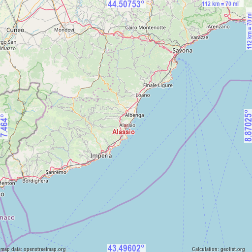
Alassio GPS coordinates[2]
44° 0' 14.148" North, 8° 10' 1.668" East
| Map corner | latitude | longitude |
|---|---|---|
| Upper-left | 44.50753°, | 7.464° |
| Center: | 44.00393°, | 8.16713° |
| Lower-right: | 43.49602°, | 8.87025° |
| Map W x H: | 112.5×112.5 km | = 69.9×69.9mi |
| max Lat: | 47.04031° ⇑54.6% North |
| Alassio: | 44.00393° |
| min Lat: | ⇓45.4% South 35.50142° |
| min Long | Alassio | max Long |
| 6.69888° | 8.16713° | 18.48682° |
| W 8.5%⇐ | ⇒91.5% E |
Elevation
Elevation of Alassio is 12 m = 39 ft, and this is 294.7 m = 967 ft below average elevation for this country.
| Max E: |
2085 m = 6841 ft | 93% |
| Avg. | 306.7 m = 1006 ft | |
| Alassio | 12 m = 39 ft | |
Min E: |
-4 m = -13 ft | 7% |
See also: Italy elevation on elevation.city.
Geographical zone
Alassio is located in North temperate zone (between Tropic of Cancer and the Arctic Circle). Distance of this Northern Tropic circle is 2286.9 km =1421 mi to South.| Distance of | km | miles | from Alassio |
|---|---|---|---|
| North Pole | 5114.3 | 3177.9 | to North |
| Arctic Circle | 2508.4 | 1558.6 | to North |
| Tropic Cancer | 2286.9 | 1421 | to South |
| Equator | 4892.8 | 3040.2 | to South |


Nearby cities:
15 places around Alassio: (largest is in red/bold)
• Albenga
6.6 km =4.1 mi,  38°
38°
• Andora
5.8 km =3.6 mi,  200°
200°
• Bastia
6 km =3.7 mi,  3°
3°
• Campochiesa
7.8 km =4.8 mi,  17°
17°
• Garlenda
6.6 km =4.1 mi,  299°
299°
• Laigueglia
3.2 km =2 mi,  192°
192°
• Marina di Andora
5.7 km =3.5 mi, 190°
• Molino Nuovo
3.8 km =2.4 mi,  230°
230°
• Ortovero
7.7 km =4.8 mi,  315°
315°
• Pian Rosso-Costa
4 km =2.5 mi,  251°
251°
• San Fedele-Lusignano
4.8 km =3 mi,  13°
13°
• Stellanello
8.6 km =5.3 mi,  267°
267°
• Villa Faraldi
7.3 km =4.5 mi,  237°
237°
• Villafranca
5.9 km =3.7 mi, 303°
• Villanova d'Albenga
5.2 km =3.2 mi,  338°
338°
Sources, notices
• [Note1] Compared only with cities in Italy existing in our database
• [Src1] Map data: © OpenStreetMap contributors (CC-BY-SA)
• [Src2] Other city data from geonames.org with taken over terms of usage.
• [Src3] Geographical zone / Annual Mean Temperature by Robert A. Rohde @ Wikipedia
