Serravalle a Po geodata
Serravalle a Po (Lombardy) is a seat of a third-order administrative division; located in Italy in Europe/Rome (GMT+2) time zone. With population of 552 people, there are 9430 cities with bigger population in this country. Compared to other cities in Italy, 61.6% of cities are located further ↓South; 56.1% of cities are located further →East and 91.1% of cities have higher elevation than Serravalle a Po. Note1
Administrative division(s):
- Level 1: Lombardy
- Level 2: Provincia di Mantova
- Level 3: Serravalle a Po


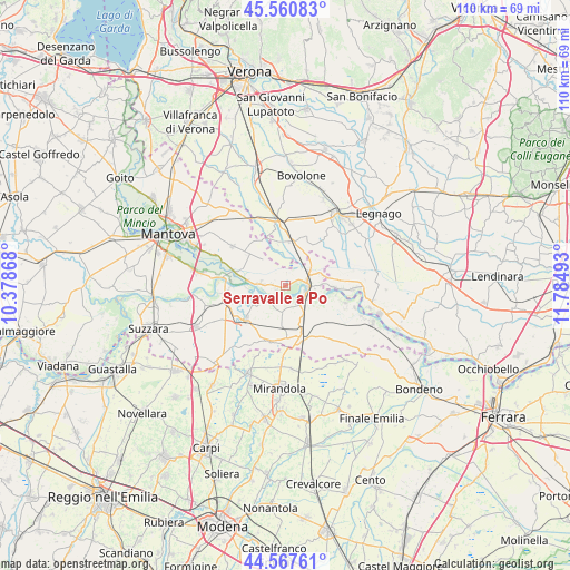
Serravalle a Po GPS coordinates[2]
45° 3' 58.968" North, 11° 4' 54.48" East
| Map corner | latitude | longitude |
|---|---|---|
| Upper-left | 45.56083°, | 10.37868° |
| Center: | 45.06638°, | 11.0818° |
| Lower-right: | 44.56761°, | 11.78493° |
| Map W x H: | 110.4×110.4 km | = 68.6×68.6mi |
| max Lat: | 47.04031° ⇑38.4% North |
| Serravalle a Po: | 45.06638° |
| min Lat: | ⇓61.6% South 35.50142° |
| min Long | Serravalle a Po | max Long |
| 6.69888° | 11.0818° | 18.48682° |
| W 43.9%⇐ | ⇒56.1% E |
Elevation
Elevation of Serravalle a Po is 16 m = 52 ft, and this is 290.7 m = 954 ft below average elevation for this country.
| Max E: |
2085 m = 6841 ft | 91.1% |
| Avg. | 306.7 m = 1006 ft | |
| Serravalle a Po | 16 m = 52 ft | |
Min E: |
-4 m = -13 ft | 8.9% |
See also: Italy elevation on elevation.city.
Geographical zone
Serravalle a Po is located in North temperate zone (between Tropic of Cancer and the Arctic Circle). Distance of this North polar circle is 2390.3 km =1485.3 mi to North.| Distance of | km | miles | from Serravalle a Po |
|---|---|---|---|
| North Pole | 4996.2 | 3104.5 | to North |
| Arctic Circle | 2390.3 | 1485.3 | to North |
| Tropic Cancer | 2405 | 1494.4 | to South |
| Equator | 5010.9 | 3113.6 | to South |


Nearby cities:
15 places around Serravalle a Po: (largest is in red/bold)
• Borgofranco sul Po
10.3 km =6.4 mi,  102°
102°
• Correggioli
6.8 km =4.2 mi,  90°
90°
• Libiola
1.7 km =1.1 mi,  255°
255°
• Maccacari
9.5 km =5.9 mi,  26°
26°
• Melara
9.4 km =5.8 mi, 91°
• Ostiglia
4.2 km =2.6 mi,  84°
84°
• Pieve di Coriano
4.2 km =2.6 mi,  150°
150°
• Quingentole
4.2 km =2.6 mi,  221°
221°
• Quistello
10.1 km =6.3 mi,  229°
229°
• Revere
4.1 km =2.5 mi,  112°
112°
• Roncanova
8.7 km =5.4 mi,  11°
11°
• Schivenoglia
8 km =5 mi,  184°
184°
• Sustinente
4.7 km =2.9 mi,  276°
276°
• Villa Poma
7.6 km =4.7 mi,  160°
160°
• Villimpenta
9.2 km =5.7 mi,  334°
334°
Sources, notices
• [Note1] Compared only with cities in Italy existing in our database
• [Src1] Map data: © OpenStreetMap contributors (CC-BY-SA)
• [Src2] Other city data from geonames.org with taken over terms of usage.
• [Src3] Geographical zone / Annual Mean Temperature by Robert A. Rohde @ Wikipedia
