Maccacari geodata
Maccacari (Veneto) is a populated place; located in Italy in Europe/Rome (GMT+2) time zone. With population of 1,488 people, there are 5142 cities with bigger population in this country. Compared to other cities in Italy, 63.6% of cities are located further ↓South; 55.4% of cities are located further →East and 92.1% of cities have higher elevation than Maccacari. Note1


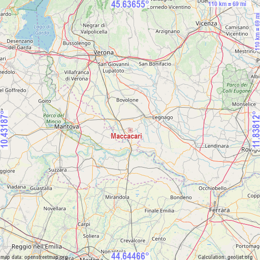
Maccacari GPS coordinates[2]
45° 8' 33.936" North, 11° 8' 5.964" East
| Map corner | latitude | longitude |
|---|---|---|
| Upper-left | 45.63655°, | 10.43187° |
| Center: | 45.14276°, | 11.13499° |
| Lower-right: | 44.64466°, | 11.83812° |
| Map W x H: | 110.3×110.3 km | = 68.5×68.5mi |
| max Lat: | 47.04031° ⇑36.4% North |
| Maccacari: | 45.14276° |
| min Lat: | ⇓63.6% South 35.50142° |
| min Long | Maccacari | max Long |
| 6.69888° | 11.13499° | 18.48682° |
| W 44.6%⇐ | ⇒55.4% E |
Elevation
Elevation of Maccacari is 14 m = 46 ft, and this is 292.7 m = 960 ft below average elevation for this country.
| Max E: |
2085 m = 6841 ft | 92.1% |
| Avg. | 306.7 m = 1006 ft | |
| Maccacari | 14 m = 46 ft | |
Min E: |
-4 m = -13 ft | 7.9% |
See also: Italy elevation on elevation.city.
Geographical zone
Maccacari is located in North temperate zone (between Tropic of Cancer and the Arctic Circle). Distance of this North polar circle is 2381.8 km =1480 mi to North.| Distance of | km | miles | from Maccacari |
|---|---|---|---|
| North Pole | 4987.7 | 3099.2 | to North |
| Arctic Circle | 2381.8 | 1480 | to North |
| Tropic Cancer | 2413.5 | 1499.7 | to South |
| Equator | 5019.4 | 3118.9 | to South |


Nearby cities:
15 places around Maccacari: (largest is in red/bold)
• Asparetto
9.4 km =5.8 mi,  23°
23°
• Bionde
6.9 km =4.3 mi,  336°
336°
• Capitello
7.3 km =4.5 mi,  3°
3°
• Casaleone
5.4 km =3.4 mi,  58°
58°
• Cerea
8.2 km =5.1 mi,  51°
51°
• Correggioli
8.9 km =5.5 mi,  162°
162°
• Melara
10.2 km =6.3 mi,  149°
149°
• Nogara
7.3 km =4.5 mi,  305°
305°
• Ostiglia
8.1 km =5 mi,  180°
180°
• Piazza
8.1 km =5 mi, 4°
• Revere
10.1 km =6.3 mi, 181°
• Roncanova
2.5 km =1.6 mi,  271°
271°
• Sanguinetto
4.8 km =3 mi,  8°
8°
• Serravalle a Po
9.5 km =5.9 mi,  206°
206°
• Villimpenta
8.1 km =5 mi, 268°
Sources, notices
• [Note1] Compared only with cities in Italy existing in our database
• [Src1] Map data: © OpenStreetMap contributors (CC-BY-SA)
• [Src2] Other city data from geonames.org with taken over terms of usage.
• [Src3] Geographical zone / Annual Mean Temperature by Robert A. Rohde @ Wikipedia
