Quingentole geodata
Quingentole (Lombardy) is a seat of a third-order administrative division; located in Italy in Europe/Rome (GMT+2) time zone. With population of 927 people, there are 6993 cities with bigger population in this country. Compared to other cities in Italy, 60.9% of cities are located further ↓South; 56.6% of cities are located further →East and 91.1% of cities have higher elevation than Quingentole. Note1


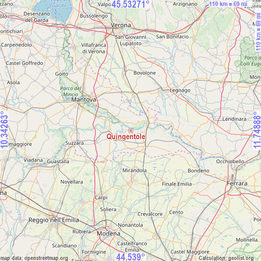
Quingentole GPS coordinates[2]
45° 2' 16.836" North, 11° 2' 44.7" East
| Map corner | latitude | longitude |
|---|---|---|
| Upper-left | 45.53271°, | 10.34263° |
| Center: | 45.03801°, | 11.04575° |
| Lower-right: | 44.539°, | 11.74888° |
| Map W x H: | 110.5×110.5 km | = 68.7×68.7mi |
| max Lat: | 47.04031° ⇑39.1% North |
| Quingentole: | 45.03801° |
| min Lat: | ⇓60.9% South 35.50142° |
| min Long | Quingentole | max Long |
| 6.69888° | 11.04575° | 18.48682° |
| W 43.4%⇐ | ⇒56.6% E |
Elevation
Elevation of Quingentole is 16 m = 52 ft, and this is 290.7 m = 954 ft below average elevation for this country.
| Max E: |
2085 m = 6841 ft | 91.1% |
| Avg. | 306.7 m = 1006 ft | |
| Quingentole | 16 m = 52 ft | |
Min E: |
-4 m = -13 ft | 8.9% |
See also: Italy elevation on elevation.city.
Geographical zone
Quingentole is located in North temperate zone (between Tropic of Cancer and the Arctic Circle). Distance of this North polar circle is 2393.4 km =1487.2 mi to North.| Distance of | km | miles | from Quingentole |
|---|---|---|---|
| North Pole | 4999.3 | 3106.4 | to North |
| Arctic Circle | 2393.4 | 1487.2 | to North |
| Tropic Cancer | 2401.8 | 1492.4 | to South |
| Equator | 5007.8 | 3111.7 | to South |


Nearby cities:
15 places around Quingentole: (largest is in red/bold)
• Correggioli
10.1 km =6.3 mi,  71°
71°
• Libiola
3 km =1.9 mi,  23°
23°
• Ostiglia
7.8 km =4.8 mi,  63°
63°
• Pieve di Coriano
4.9 km =3 mi,  95°
95°
• Poggio Rusco
9.1 km =5.7 mi,  149°
149°
• Quistello
5.9 km =3.7 mi,  235°
235°
• Revere
6.8 km =4.2 mi,  76°
76°
• San Benedetto Po
8.9 km =5.5 mi,  275°
275°
• San Giacomo delle Segnate
7.2 km =4.5 mi,  187°
187°
• San Giovanni del Dosso
8.4 km =5.2 mi,  160°
160°
• Schivenoglia
5.2 km =3.2 mi, 155°
• Serravalle a Po
4.2 km =2.6 mi,  41°
41°
• Sustinente
4.1 km =2.5 mi,  332°
332°
• Vallalta
11 km =6.8 mi,  196°
196°
• Villa Poma
6.7 km =4.2 mi,  126°
126°
Sources, notices
• [Note1] Compared only with cities in Italy existing in our database
• [Src1] Map data: © OpenStreetMap contributors (CC-BY-SA)
• [Src2] Other city data from geonames.org with taken over terms of usage.
• [Src3] Geographical zone / Annual Mean Temperature by Robert A. Rohde @ Wikipedia
