Villagrande geodata
Villagrande (The Marches) is a seat of a third-order administrative division; located in Italy in Europe/Rome (GMT+2) time zone. With population of 510 people, there are 9825 cities with bigger population in this country. Compared to other cities in Italy, 56.5% of cities are located further ↑North; 60.8% of cities are located further ←West and 95.7% of cities have lower elevation than Villagrande. Note1
Administrative division(s):
- Level 1: The Marches
- Level 2: Provincia di Pesaro e Urbino
- Level 3: Montecopiolo


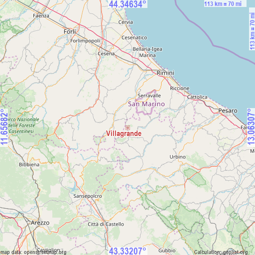
Villagrande GPS coordinates[2]
43° 50' 28.896" North, 12° 21' 35.784" East
| Map corner | latitude | longitude |
|---|---|---|
| Upper-left | 44.34634°, | 11.65682° |
| Center: | 43.84136°, | 12.35994° |
| Lower-right: | 43.33207°, | 13.06307° |
| Map W x H: | 112.8×112.8 km | = 70.1×70.1mi |
| max Lat: | 47.04031° ⇑56.5% North |
| Villagrande: | 43.84136° |
| min Lat: | ⇓43.5% South 35.50142° |
| min Long | Villagrande | max Long |
| 6.69888° | 12.35994° | 18.48682° |
| W 60.8%⇐ | ⇒39.2% E |
Elevation
Elevation of Villagrande is 913 m = 2995 ft, and this is 606.3 m = 1989 ft above average elevation for this country.
| Max E: |
2085 m = 6841 ft | 4.3% |
| Villagrande | 913 m 2995 ft | |
| Avg. | 306.7 m = 1006 ft | |
Min E: |
-4 m = -13 ft | 95.7% |
See also: Italy elevation on elevation.city.
Geographical zone
Villagrande is located in North temperate zone (between Tropic of Cancer and the Arctic Circle). Distance of this Northern Tropic circle is 2268.8 km =1409.8 mi to South.| Distance of | km | miles | from Villagrande |
|---|---|---|---|
| North Pole | 5132.4 | 3189.1 | to North |
| Arctic Circle | 2526.5 | 1569.9 | to North |
| Tropic Cancer | 2268.8 | 1409.8 | to South |
| Equator | 4874.7 | 3029 | to South |


Nearby cities:
15 places around Villagrande: (largest is in red/bold)
• Ca' Fusino
8.8 km =5.5 mi,  321°
321°
• Carpegna
7 km =4.3 mi,  196°
196°
• Frontino
8.6 km =5.3 mi,  171°
171°
• Macerata Feltria
7.9 km =4.9 mi,  123°
123°
• Mercatale
11.9 km =7.4 mi, 123°
• Mercatino Conca
11 km =6.8 mi,  73°
73°
• Mercato Vecchio
4.3 km =2.7 mi,  162°
162°
• Monte Cerignone
4.4 km =2.7 mi,  92°
92°
• Monte Grimano Terme
9.4 km =5.8 mi, 71°
• Novafeltria
8.2 km =5.1 mi, 316°
• Pennabilli
7.9 km =4.9 mi,  250°
250°
• San Leo
6.2 km =3.9 mi,  348°
348°
• Secchiano
9.8 km =6.1 mi,  339°
339°
• Serra di Maiolo
5.3 km =3.3 mi,  312°
312°
• Talamello
9.3 km =5.8 mi, 319°
Sources, notices
• [Note1] Compared only with cities in Italy existing in our database
• [Src1] Map data: © OpenStreetMap contributors (CC-BY-SA)
• [Src2] Other city data from geonames.org with taken over terms of usage.
• [Src3] Geographical zone / Annual Mean Temperature by Robert A. Rohde @ Wikipedia
