San Leo geodata
San Leo (Emilia-Romagna) is a seat of a third-order administrative division; located in Italy in Europe/Rome (GMT+2) time zone. With population of 204 people, there are 11115 cities with bigger population in this country. Compared to other cities in Italy, 55.8% of cities are located further ↑North; 60.6% of cities are located further ←West and 84.7% of cities have lower elevation than San Leo. Note1


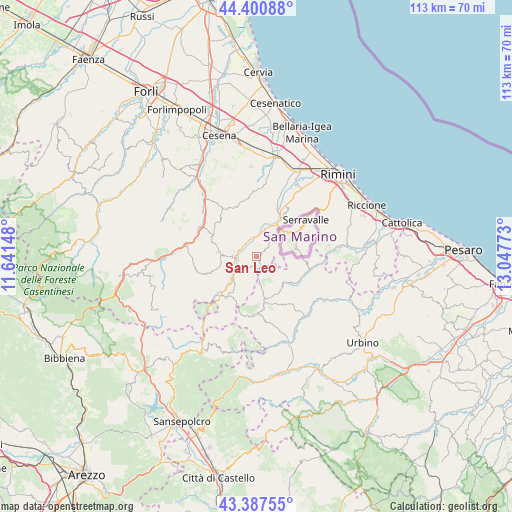
San Leo GPS coordinates[2]
43° 53' 46.932" North, 12° 20' 40.56" East
| Map corner | latitude | longitude |
|---|---|---|
| Upper-left | 44.40088°, | 11.64148° |
| Center: | 43.89637°, | 12.3446° |
| Lower-right: | 43.38755°, | 13.04773° |
| Map W x H: | 112.7×112.7 km | = 70×70mi |
| max Lat: | 47.04031° ⇑55.8% North |
| San Leo: | 43.89637° |
| min Lat: | ⇓44.2% South 35.50142° |
| min Long | San Leo | max Long |
| 6.69888° | 12.3446° | 18.48682° |
| W 60.6%⇐ | ⇒39.4% E |
Elevation
Elevation of San Leo is 605 m = 1985 ft, and this is 298.3 m = 979 ft above average elevation for this country.
| Max E: |
2085 m = 6841 ft | 15.3% |
| San Leo | 605 m 1985 ft | |
| Avg. | 306.7 m = 1006 ft | |
Min E: |
-4 m = -13 ft | 84.7% |
See also: Italy elevation on elevation.city.
Geographical zone
San Leo is located in North temperate zone (between Tropic of Cancer and the Arctic Circle). Distance of this Northern Tropic circle is 2274.9 km =1413.6 mi to South.| Distance of | km | miles | from San Leo |
|---|---|---|---|
| North Pole | 5126.2 | 3185.3 | to North |
| Arctic Circle | 2520.4 | 1566.1 | to North |
| Tropic Cancer | 2274.9 | 1413.6 | to South |
| Equator | 4880.8 | 3032.8 | to South |


Nearby cities:
15 places around San Leo: (largest is in red/bold)
• Ca' Fusino
4.4 km =2.7 mi,  279°
279°
• Mercato Vecchio
10.6 km =6.6 mi,  165°
165°
• Monte Cerignone
8.4 km =5.2 mi,  138°
138°
• Monte Grimano Terme
10.6 km =6.6 mi,  107°
107°
• Novafeltria
4.5 km =2.8 mi,  267°
267°
• Pennabilli
10.8 km =6.7 mi,  215°
215°
• Perticara
8.3 km =5.2 mi, 277°
• Pietracuta
6.8 km =4.2 mi,  18°
18°
• Sant'Agata Feltria
11.6 km =7.2 mi,  251°
251°
• Secchiano
3.8 km =2.4 mi,  323°
323°
• Serra di Maiolo
3.7 km =2.3 mi,  225°
225°
• Talamello
4.9 km =3 mi, 282°
• Torriana
10.4 km =6.5 mi, 18°
• Verucchio
11.4 km =7.1 mi,  33°
33°
• Villagrande
6.2 km =3.9 mi, 168°
Sources, notices
• [Note1] Compared only with cities in Italy existing in our database
• [Src1] Map data: © OpenStreetMap contributors (CC-BY-SA)
• [Src2] Other city data from geonames.org with taken over terms of usage.
• [Src3] Geographical zone / Annual Mean Temperature by Robert A. Rohde @ Wikipedia
