Castel di Lama geodata
Castel di Lama (The Marches) is a seat of a third-order administrative division; located in Italy in Europe/Rome (GMT+2) time zone. With population of 7,216 people, there are 1352 cities with bigger population in this country. Compared to other cities in Italy, 64.3% of cities are located further ↑North; 75.8% of cities are located further ←West and 73.4% of cities have higher elevation than Castel di Lama. Note1
Administrative division(s):
- Level 1: The Marches
- Level 2: Provincia di Ascoli Piceno
- Level 3: Castel di Lama


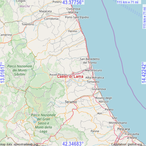
Castel di Lama GPS coordinates[2]
42° 51' 51.66" North, 13° 43' 9.444" East
| Map corner | latitude | longitude |
|---|---|---|
| Upper-left | 43.37756°, | 13.01617° |
| Center: | 42.86435°, | 13.71929° |
| Lower-right: | 42.34683°, | 14.42242° |
| Map W x H: | 114.6×114.6 km | = 71.2×71.2mi |
| max Lat: | 47.04031° ⇑64.3% North |
| Castel di Lama: | 42.86435° |
| min Lat: | ⇓35.7% South 35.50142° |
| min Long | Castel di Lama | max Long |
| 6.69888° | 13.71929° | 18.48682° |
| W 75.8%⇐ | ⇒24.2% E |
Elevation
Elevation of Castel di Lama is 81 m = 266 ft, and this is 225.7 m = 740 ft below average elevation for this country.
| Max E: |
2085 m = 6841 ft | 73.4% |
| Avg. | 306.7 m = 1006 ft | |
| Castel di Lama | 81 m = 266 ft | |
Min E: |
-4 m = -13 ft | 26.6% |
See also: Italy elevation on elevation.city.
Geographical zone
Castel di Lama is located in North temperate zone (between Tropic of Cancer and the Arctic Circle). Distance of this Northern Tropic circle is 2160.1 km =1342.2 mi to South.| Distance of | km | miles | from Castel di Lama |
|---|---|---|---|
| North Pole | 5241 | 3256.6 | to North |
| Arctic Circle | 2635.1 | 1637.4 | to North |
| Tropic Cancer | 2160.1 | 1342.2 | to South |
| Equator | 4766.1 | 2961.5 | to South |


Nearby cities:
15 places around Castel di Lama: (largest is in red/bold)
• Ancarano
3.7 km =2.3 mi,  143°
143°
• Appignano del Tronto
6 km =3.7 mi,  308°
308°
• Campolungo-Villa Sant'Antonio
3.3 km =2.1 mi,  241°
241°
• Caselle
4.6 km =2.9 mi, 237°
• Castorano
3.8 km =2.4 mi,  12°
12°
• Colli del Tronto
2.7 km =1.7 mi,  58°
58°
• Maltignano
4.4 km =2.7 mi,  215°
215°
• Monsampolo del Tronto
7.1 km =4.4 mi, 58°
• Pagliare
4.1 km =2.5 mi,  82°
82°
• Piattoni-Villa Sant'Antonio
0.7 km =0.4 mi,  288°
288°
• San Silvestro
0.8 km =0.5 mi,  67°
67°
• Sant'Egidio alla Vibrata
5.3 km =3.3 mi,  177°
177°
• Spinetoli
4.7 km =2.9 mi,  52°
52°
• Torano Nuovo
6.6 km =4.1 mi,  134°
134°
• Villa San Giuseppe
2.1 km =1.3 mi, 77°
Sources, notices
• [Note1] Compared only with cities in Italy existing in our database
• [Src1] Map data: © OpenStreetMap contributors (CC-BY-SA)
• [Src2] Other city data from geonames.org with taken over terms of usage.
• [Src3] Geographical zone / Annual Mean Temperature by Robert A. Rohde @ Wikipedia
