Castorano geodata
Castorano (The Marches) is a seat of a third-order administrative division; located in Italy in Europe/Rome (GMT+2) time zone. With population of 757 people, there are 7901 cities with bigger population in this country. Compared to other cities in Italy, 63.9% of cities are located further ↑North; 75.9% of cities are located further ←West and 54.9% of cities have lower elevation than Castorano. Note1
Administrative division(s):
- Level 1: The Marches
- Level 2: Provincia di Ascoli Piceno
- Level 3: Castorano


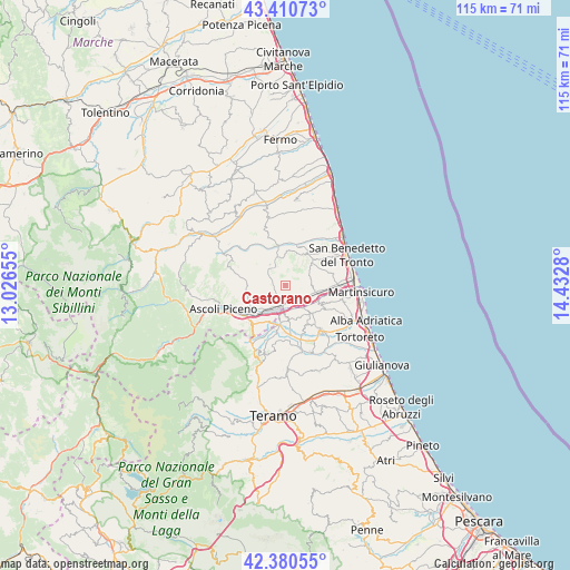
Castorano GPS coordinates[2]
42° 53' 52.044" North, 13° 43' 46.812" East
| Map corner | latitude | longitude |
|---|---|---|
| Upper-left | 43.41073°, | 13.02655° |
| Center: | 42.89779°, | 13.72967° |
| Lower-right: | 42.38055°, | 14.4328° |
| Map W x H: | 114.5×114.5 km | = 71.1×71.1mi |
| max Lat: | 47.04031° ⇑63.9% North |
| Castorano: | 42.89779° |
| min Lat: | ⇓36.1% South 35.50142° |
| min Long | Castorano | max Long |
| 6.69888° | 13.72967° | 18.48682° |
| W 75.9%⇐ | ⇒24.1% E |
Elevation
Elevation of Castorano is 265 m = 869 ft, and this is 41.7 m = 137 ft below average elevation for this country.
| Max E: |
2085 m = 6841 ft | 45.1% |
| Avg. | 306.7 m = 1006 ft | |
| Castorano | 265 m = 869 ft | |
Min E: |
-4 m = -13 ft | 54.9% |
See also: Italy elevation on elevation.city.
Geographical zone
Castorano is located in North temperate zone (between Tropic of Cancer and the Arctic Circle). Distance of this Northern Tropic circle is 2163.9 km =1344.6 mi to South.| Distance of | km | miles | from Castorano |
|---|---|---|---|
| North Pole | 5237.3 | 3254.3 | to North |
| Arctic Circle | 2631.4 | 1635.1 | to North |
| Tropic Cancer | 2163.9 | 1344.6 | to South |
| Equator | 4769.8 | 2963.8 | to South |


Nearby cities:
15 places around Castorano: (largest is in red/bold)
• Ancarano
6.8 km =4.2 mi,  168°
168°
• Appignano del Tronto
5.5 km =3.4 mi,  270°
270°
• Campolungo-Villa Sant'Antonio
6.5 km =4 mi,  215°
215°
• Caselle
7.8 km =4.8 mi, 217°
• Castel di Lama
3.8 km =2.4 mi,  192°
192°
• Colli del Tronto
2.7 km =1.7 mi,  148°
148°
• Maltignano
8 km =5 mi,  204°
204°
• Monsampolo del Tronto
5.2 km =3.2 mi,  90°
90°
• Offida
4.9 km =3 mi,  327°
327°
• Pagliare
4.5 km =2.8 mi,  134°
134°
• Piattoni-Villa Sant'Antonio
3.8 km =2.4 mi, 203°
• San Silvestro
3.4 km =2.1 mi,  181°
181°
• Spinetoli
3 km =1.9 mi,  107°
107°
• Stella
6.6 km =4.1 mi,  100°
100°
• Villa San Giuseppe
3.5 km =2.2 mi,  159°
159°
Sources, notices
• [Note1] Compared only with cities in Italy existing in our database
• [Src1] Map data: © OpenStreetMap contributors (CC-BY-SA)
• [Src2] Other city data from geonames.org with taken over terms of usage.
• [Src3] Geographical zone / Annual Mean Temperature by Robert A. Rohde @ Wikipedia
