Pagliare geodata
Pagliare (The Marches) is a populated place; located in Italy in Europe/Rome (GMT+2) time zone. With population of 4,847 people, there are 2019 cities with bigger population in this country. Compared to other cities in Italy, 64.2% of cities are located further ↑North; 76.3% of cities are located further ←West and 82% of cities have higher elevation than Pagliare. Note1
Administrative division(s):
- Level 1: The Marches
- Level 2: Provincia di Ascoli Piceno
- Level 3: Spinetoli


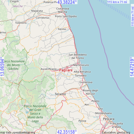
Pagliare GPS coordinates[2]
42° 52' 8.616" North, 13° 46' 8.616" East
| Map corner | latitude | longitude |
|---|---|---|
| Upper-left | 43.38224°, | 13.06594° |
| Center: | 42.86906°, | 13.76906° |
| Lower-right: | 42.35158°, | 14.47219° |
| Map W x H: | 114.6×114.6 km | = 71.2×71.2mi |
| max Lat: | 47.04031° ⇑64.2% North |
| Pagliare: | 42.86906° |
| min Lat: | ⇓35.8% South 35.50142° |
| min Long | Pagliare | max Long |
| 6.69888° | 13.76906° | 18.48682° |
| W 76.3%⇐ | ⇒23.7% E |
Elevation
Elevation of Pagliare is 42 m = 138 ft, and this is 264.7 m = 868 ft below average elevation for this country.
| Max E: |
2085 m = 6841 ft | 82% |
| Avg. | 306.7 m = 1006 ft | |
| Pagliare | 42 m = 138 ft | |
Min E: |
-4 m = -13 ft | 18% |
See also: Italy elevation on elevation.city.
Geographical zone
Pagliare is located in North temperate zone (between Tropic of Cancer and the Arctic Circle). Distance of this Northern Tropic circle is 2160.7 km =1342.6 mi to South.| Distance of | km | miles | from Pagliare |
|---|---|---|---|
| North Pole | 5240.5 | 3256.3 | to North |
| Arctic Circle | 2634.6 | 1637.1 | to North |
| Tropic Cancer | 2160.7 | 1342.6 | to South |
| Equator | 4766.6 | 2961.8 | to South |


Nearby cities:
15 places around Pagliare: (largest is in red/bold)
• Ancarano
3.9 km =2.4 mi,  207°
207°
• Castel di Lama
4.1 km =2.5 mi,  262°
262°
• Castorano
4.5 km =2.8 mi,  314°
314°
• Centobuchi
7.1 km =4.4 mi,  65°
65°
• Colli del Tronto
2 km =1.2 mi,  296°
296°
• Controguerra
4.3 km =2.7 mi,  112°
112°
• Corropoli
7.1 km =4.4 mi,  131°
131°
• Monsampolo del Tronto
3.7 km =2.3 mi,  32°
32°
• Piattoni-Villa Sant'Antonio
4.7 km =2.9 mi,  266°
266°
• San Silvestro
3.3 km =2.1 mi, 266°
• Sant'Egidio alla Vibrata
7 km =4.3 mi, 213°
• Spinetoli
2.3 km =1.4 mi,  351°
351°
• Stella
3.8 km =2.4 mi,  58°
58°
• Torano Nuovo
5.2 km =3.2 mi,  172°
172°
• Villa San Giuseppe
2 km =1.2 mi, 268°
Sources, notices
• [Note1] Compared only with cities in Italy existing in our database
• [Src1] Map data: © OpenStreetMap contributors (CC-BY-SA)
• [Src2] Other city data from geonames.org with taken over terms of usage.
• [Src3] Geographical zone / Annual Mean Temperature by Robert A. Rohde @ Wikipedia
