Certaldo geodata
Certaldo (Tuscany) is a seat of a third-order administrative division; located in Italy in Europe/Rome (GMT+2) time zone. With population of 12,981 people, there are 709 cities with bigger population in this country. Compared to other cities in Italy, 59.4% of cities are located further ↑North; 56.7% of cities are located further →East and 75.6% of cities have higher elevation than Certaldo. Note1


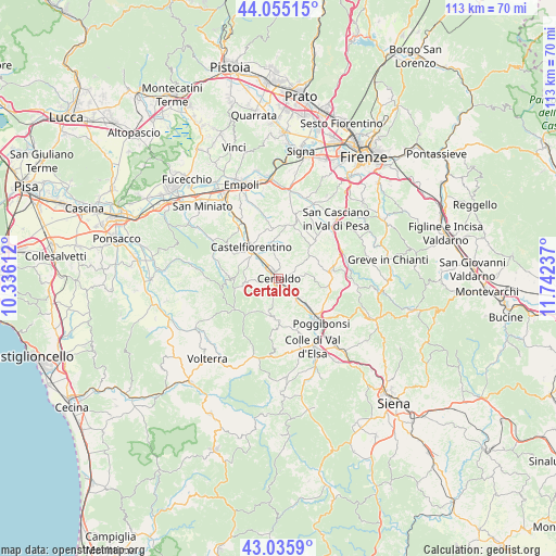
Certaldo GPS coordinates[2]
43° 32' 51.648" North, 11° 2' 21.264" East
| Map corner | latitude | longitude |
|---|---|---|
| Upper-left | 44.05515°, | 10.33612° |
| Center: | 43.54768°, | 11.03924° |
| Lower-right: | 43.0359°, | 11.74237° |
| Map W x H: | 113.3×113.3 km | = 70.4×70.4mi |
| max Lat: | 47.04031° ⇑59.4% North |
| Certaldo: | 43.54768° |
| min Lat: | ⇓40.6% South 35.50142° |
| min Long | Certaldo | max Long |
| 6.69888° | 11.03924° | 18.48682° |
| W 43.3%⇐ | ⇒56.7% E |
Elevation
Elevation of Certaldo is 71 m = 233 ft, and this is 235.7 m = 773 ft below average elevation for this country.
| Max E: |
2085 m = 6841 ft | 75.6% |
| Avg. | 306.7 m = 1006 ft | |
| Certaldo | 71 m = 233 ft | |
Min E: |
-4 m = -13 ft | 24.4% |
See also: Italy elevation on elevation.city.
Geographical zone
Certaldo is located in North temperate zone (between Tropic of Cancer and the Arctic Circle). Distance of this Northern Tropic circle is 2236.1 km =1389.4 mi to South.| Distance of | km | miles | from Certaldo |
|---|---|---|---|
| North Pole | 5165 | 3209.4 | to North |
| Arctic Circle | 2559.1 | 1590.2 | to North |
| Tropic Cancer | 2236.1 | 1389.4 | to South |
| Equator | 4842 | 3008.7 | to South |


Nearby cities:
15 places around Certaldo: (largest is in red/bold)
• Badia A Elmi
1.1 km =0.7 mi,  209°
209°
• Badia a Cerreto
1.1 km =0.7 mi,  261°
261°
• Barberino Val d'Elsa
10.7 km =6.6 mi,  94°
94°
• Cambiano
11.4 km =7.1 mi,  326°
326°
• Case Nuove
6.9 km =4.3 mi,  301°
301°
• Castelfiorentino
9 km =5.6 mi,  320°
320°
• Castelnuovo d'Elsa
12.7 km =7.9 mi, 319°
• Dogana
10.4 km =6.5 mi, 316°
• Gambassi Terme
7.2 km =4.5 mi, 259°
• Montaione
10.1 km =6.3 mi,  272°
272°
• Montespertoli
10.9 km =6.8 mi,  14°
14°
• Poggibonsi
12.3 km =7.6 mi,  134°
134°
• San Gimignano
8.3 km =5.2 mi,  185°
185°
• Tavarnelle Val di Pesa
10.8 km =6.7 mi,  81°
81°
• Ulignano
5.8 km =3.6 mi,  143°
143°
Sources, notices
• [Note1] Compared only with cities in Italy existing in our database
• [Src1] Map data: © OpenStreetMap contributors (CC-BY-SA)
• [Src2] Other city data from geonames.org with taken over terms of usage.
• [Src3] Geographical zone / Annual Mean Temperature by Robert A. Rohde @ Wikipedia
