Avegno geodata
Avegno (Liguria) is a seat of a third-order administrative division; located in Italy in Europe/Rome (GMT+2) time zone. With population of 2,151 people, there are 3932 cities with bigger population in this country. Compared to other cities in Italy, 50.7% of cities are located further ↑North; 78.7% of cities are located further →East and 78.3% of cities have higher elevation than Avegno. Note1


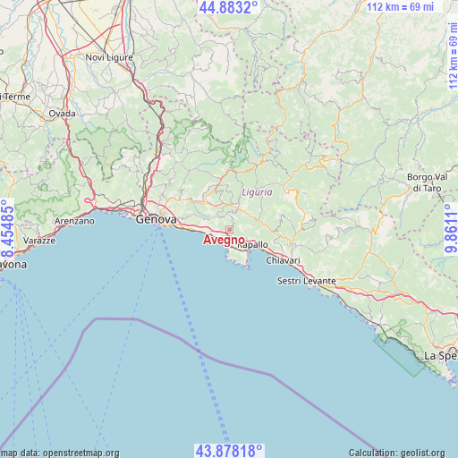
Avegno GPS coordinates[2]
44° 22' 58.26" North, 9° 9' 28.692" East
| Map corner | latitude | longitude |
|---|---|---|
| Upper-left | 44.8832°, | 8.45485° |
| Center: | 44.38285°, | 9.15797° |
| Lower-right: | 43.87818°, | 9.8611° |
| Map W x H: | 111.7×111.7 km | = 69.4×69.4mi |
| max Lat: | 47.04031° ⇑50.7% North |
| Avegno: | 44.38285° |
| min Lat: | ⇓49.3% South 35.50142° |
| min Long | Avegno | max Long |
| 6.69888° | 9.15797° | 18.48682° |
| W 21.3%⇐ | ⇒78.7% E |
Elevation
Elevation of Avegno is 58 m = 190 ft, and this is 248.7 m = 816 ft below average elevation for this country.
| Max E: |
2085 m = 6841 ft | 78.3% |
| Avg. | 306.7 m = 1006 ft | |
| Avegno | 58 m = 190 ft | |
Min E: |
-4 m = -13 ft | 21.7% |
See also: Italy elevation on elevation.city.
Geographical zone
Avegno is located in North temperate zone (between Tropic of Cancer and the Arctic Circle). Distance of this Northern Tropic circle is 2329 km =1447.2 mi to South.| Distance of | km | miles | from Avegno |
|---|---|---|---|
| North Pole | 5072.2 | 3151.7 | to North |
| Arctic Circle | 2466.3 | 1532.5 | to North |
| Tropic Cancer | 2329 | 1447.2 | to South |
| Equator | 4934.9 | 3066.4 | to South |


Nearby cities:
15 places around Avegno: (largest is in red/bold)
• Avegno Chiesa
0.7 km =0.4 mi,  40°
40°
• Camogli
3.7 km =2.3 mi,  183°
183°
• Ferrada
5.9 km =3.7 mi,  45°
45°
• Ferriere
6.9 km =4.3 mi,  345°
345°
• Gattorna
5.7 km =3.5 mi,  22°
22°
• Moconesi
5.9 km =3.7 mi, 44°
• Pieve Ligure
5.2 km =3.2 mi,  260°
260°
• Poggio Favaro-San Bernardo
6.3 km =3.9 mi,  269°
269°
• Rapallo
6.7 km =4.2 mi,  123°
123°
• Recco
2.6 km =1.6 mi,  206°
206°
• Santa Margherita Ligure
6.9 km =4.3 mi,  141°
141°
• Sori
4.4 km =2.7 mi, 255°
• Testana
1.7 km =1.1 mi,  326°
326°
• Tribogna
4.8 km =3 mi, 38°
• Uscio
3.3 km =2.1 mi,  5°
5°
Sources, notices
• [Note1] Compared only with cities in Italy existing in our database
• [Src1] Map data: © OpenStreetMap contributors (CC-BY-SA)
• [Src2] Other city data from geonames.org with taken over terms of usage.
• [Src3] Geographical zone / Annual Mean Temperature by Robert A. Rohde @ Wikipedia
