Sori geodata
Sori (Liguria) is a seat of a third-order administrative division; located in Italy in Europe/Rome (GMT+2) time zone. With population of 2,888 people, there are 3127 cities with bigger population in this country. Compared to other cities in Italy, 50.9% of cities are located further ↑North; 79.6% of cities are located further →East and 93.6% of cities have higher elevation than Sori. Note1


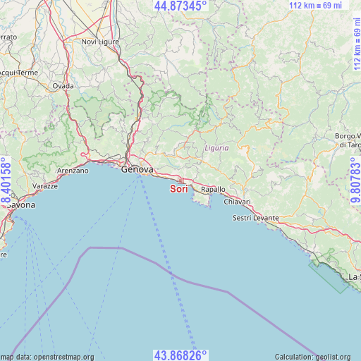
Sori GPS coordinates[2]
44° 22' 22.836" North, 9° 6' 16.92" East
| Map corner | latitude | longitude |
|---|---|---|
| Upper-left | 44.87345°, | 8.40158° |
| Center: | 44.37301°, | 9.1047° |
| Lower-right: | 43.86826°, | 9.80783° |
| Map W x H: | 111.8×111.8 km | = 69.5×69.5mi |
| max Lat: | 47.04031° ⇑50.9% North |
| Sori: | 44.37301° |
| min Lat: | ⇓49.1% South 35.50142° |
| min Long | Sori | max Long |
| 6.69888° | 9.1047° | 18.48682° |
| W 20.4%⇐ | ⇒79.6% E |
Elevation
Elevation of Sori is 11 m = 36 ft, and this is 295.7 m = 970 ft below average elevation for this country.
| Max E: |
2085 m = 6841 ft | 93.6% |
| Avg. | 306.7 m = 1006 ft | |
| Sori | 11 m = 36 ft | |
Min E: |
-4 m = -13 ft | 6.4% |
See also: Italy elevation on elevation.city.
Geographical zone
Sori is located in North temperate zone (between Tropic of Cancer and the Arctic Circle). Distance of this Northern Tropic circle is 2327.9 km =1446.5 mi to South.| Distance of | km | miles | from Sori |
|---|---|---|---|
| North Pole | 5073.2 | 3152.3 | to North |
| Arctic Circle | 2467.4 | 1533.2 | to North |
| Tropic Cancer | 2327.9 | 1446.5 | to South |
| Equator | 4933.8 | 3065.7 | to South |


Nearby cities:
15 places around Sori: (largest is in red/bold)
• Avegno
4.4 km =2.7 mi,  75°
75°
• Avegno Chiesa
5 km =3.1 mi,  70°
70°
• Bargagli
8.3 km =5.2 mi,  353°
353°
• Bogliasco
2.9 km =1.8 mi,  286°
286°
• Camogli
4.8 km =3 mi,  123°
123°
• Ferriere
8.2 km =5.1 mi,  18°
18°
• Gattorna
9.1 km =5.7 mi,  44°
44°
• Moconesi
9.9 km =6.2 mi,  57°
57°
• Pieve Ligure
0.9 km =0.6 mi,  284°
284°
• Poggio Favaro-San Bernardo
2.3 km =1.4 mi,  297°
297°
• Recco
3.3 km =2.1 mi,  111°
111°
• Santa Margherita Ligure
9.5 km =5.9 mi, 116°
• Testana
4.1 km =2.5 mi,  52°
52°
• Tribogna
8.7 km =5.4 mi, 56°
• Uscio
6.3 km =3.9 mi, 46°
Sources, notices
• [Note1] Compared only with cities in Italy existing in our database
• [Src1] Map data: © OpenStreetMap contributors (CC-BY-SA)
• [Src2] Other city data from geonames.org with taken over terms of usage.
• [Src3] Geographical zone / Annual Mean Temperature by Robert A. Rohde @ Wikipedia
