Preseglie geodata
Preseglie (Lombardy) is a seat of a third-order administrative division; located in Italy in Europe/Rome (GMT+2) time zone. With population of 1,477 people, there are 5176 cities with bigger population in this country. Compared to other cities in Italy, 79.8% of cities are located further ↓South; 64% of cities are located further →East and 70% of cities have lower elevation than Preseglie. Note1


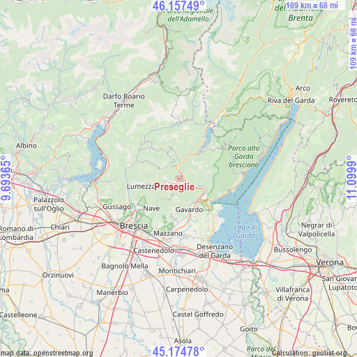
Preseglie GPS coordinates[2]
45° 40' 5.844" North, 10° 23' 48.372" East
| Map corner | latitude | longitude |
|---|---|---|
| Upper-left | 46.15749°, | 9.69365° |
| Center: | 45.66829°, | 10.39677° |
| Lower-right: | 45.17478°, | 11.0999° |
| Map W x H: | 109.3×109.3 km | = 67.9×67.9mi |
| max Lat: | 47.04031° ⇑20.2% North |
| Preseglie: | 45.66829° |
| min Lat: | ⇓79.8% South 35.50142° |
| min Long | Preseglie | max Long |
| 6.69888° | 10.39677° | 18.48682° |
| W 36%⇐ | ⇒64% E |
Elevation
Elevation of Preseglie is 394 m = 1293 ft, and this is 87.3 m = 286 ft above average elevation for this country.
| Max E: |
2085 m = 6841 ft | 30% |
| Preseglie | 394 m 1293 ft | |
| Avg. | 306.7 m = 1006 ft | |
Min E: |
-4 m = -13 ft | 70% |
See also: Italy elevation on elevation.city.
Geographical zone
Preseglie is located in North temperate zone (between Tropic of Cancer and the Arctic Circle). Distance of this North polar circle is 2323.3 km =1443.6 mi to North.| Distance of | km | miles | from Preseglie |
|---|---|---|---|
| North Pole | 4929.2 | 3062.9 | to North |
| Arctic Circle | 2323.3 | 1443.6 | to North |
| Tropic Cancer | 2471.9 | 1536 | to South |
| Equator | 5077.8 | 3155.2 | to South |


Nearby cities:
15 places around Preseglie: (largest is in red/bold)
• Agnosine
4 km =2.5 mi,  238°
238°
• Barghe
1.4 km =0.9 mi,  37°
37°
• Bione
4.5 km =2.8 mi,  276°
276°
• Carpeneda
5.9 km =3.7 mi,  112°
112°
• Case Nuove
6.5 km =4 mi,  181°
181°
• Cedessano
3.7 km =2.3 mi,  52°
52°
• Gazzane
1.8 km =1.1 mi,  228°
228°
• Mura
6.5 km =4 mi,  319°
319°
• Odolo
2.7 km =1.7 mi,  202°
202°
• Provaglio Val Sabbia
3.7 km =2.3 mi, 51°
• Sabbio Chiese
2.4 km =1.5 mi,  125°
125°
• San Faustino
4.1 km =2.5 mi,  266°
266°
• Sottocastello
0.2 km =0.1 mi, 239°
• Vallio Terme
6.5 km =4 mi, 179°
• Vestone
4.4 km =2.7 mi,  359°
359°
Sources, notices
• [Note1] Compared only with cities in Italy existing in our database
• [Src1] Map data: © OpenStreetMap contributors (CC-BY-SA)
• [Src2] Other city data from geonames.org with taken over terms of usage.
• [Src3] Geographical zone / Annual Mean Temperature by Robert A. Rohde @ Wikipedia
