Mura geodata
Mura (Lombardy) is a seat of a third-order administrative division; located in Italy in Europe/Rome (GMT+2) time zone. With population of 366 people, there are 10407 cities with bigger population in this country. Compared to other cities in Italy, 81.8% of cities are located further ↓South; 64.6% of cities are located further →East and 89.1% of cities have lower elevation than Mura. Note1


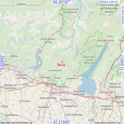
Mura GPS coordinates[2]
45° 42' 47.052" North, 10° 20' 31.344" East
| Map corner | latitude | longitude |
|---|---|---|
| Upper-left | 46.20187°, | 9.63892° |
| Center: | 45.71307°, | 10.34204° |
| Lower-right: | 45.21995°, | 11.04517° |
| Map W x H: | 109.2×109.2 km | = 67.9×67.9mi |
| max Lat: | 47.04031° ⇑18.2% North |
| Mura: | 45.71307° |
| min Lat: | ⇓81.8% South 35.50142° |
| min Long | Mura | max Long |
| 6.69888° | 10.34204° | 18.48682° |
| W 35.4%⇐ | ⇒64.6% E |
Elevation
Elevation of Mura is 696 m = 2283 ft, and this is 389.3 m = 1277 ft above average elevation for this country.
| Max E: |
2085 m = 6841 ft | 10.9% |
| Mura | 696 m 2283 ft | |
| Avg. | 306.7 m = 1006 ft | |
Min E: |
-4 m = -13 ft | 89.1% |
See also: Italy elevation on elevation.city.
Geographical zone
Mura is located in North temperate zone (between Tropic of Cancer and the Arctic Circle). Distance of this North polar circle is 2318.4 km =1440.6 mi to North.| Distance of | km | miles | from Mura |
|---|---|---|---|
| North Pole | 4924.2 | 3059.8 | to North |
| Arctic Circle | 2318.4 | 1440.6 | to North |
| Tropic Cancer | 2476.9 | 1539.1 | to South |
| Equator | 5082.8 | 3158.3 | to South |


Nearby cities:
15 places around Mura: (largest is in red/bold)
• Barghe
6.4 km =4 mi,  127°
127°
• Bione
4.5 km =2.8 mi,  183°
183°
• Briale
2.2 km =1.4 mi,  241°
241°
• Casto
2.6 km =1.6 mi,  218°
218°
• Dosso-Ville
6.9 km =4.3 mi,  309°
309°
• Gazzane
6.8 km =4.2 mi,  154°
154°
• Lodrino
5.1 km =3.2 mi,  278°
278°
• Marmentino
6.4 km =4 mi,  316°
316°
• Pertica Alta
3.3 km =2.1 mi,  2°
2°
• Pertica Bassa
5.1 km =3.2 mi,  27°
27°
• Preseglie
6.5 km =4 mi,  139°
139°
• San Faustino
5.2 km =3.2 mi, 178°
• Sottocastello
6.5 km =4 mi, 141°
• Vestone
4.2 km =2.6 mi,  97°
97°
• Villa
4.9 km =3 mi, 276°
Sources, notices
• [Note1] Compared only with cities in Italy existing in our database
• [Src1] Map data: © OpenStreetMap contributors (CC-BY-SA)
• [Src2] Other city data from geonames.org with taken over terms of usage.
• [Src3] Geographical zone / Annual Mean Temperature by Robert A. Rohde @ Wikipedia
