Barghe geodata
Barghe (Lombardy) is a seat of a third-order administrative division; located in Italy in Europe/Rome (GMT+2) time zone. With population of 867 people, there are 7328 cities with bigger population in this country. Compared to other cities in Italy, 80.2% of cities are located further ↓South; 63.9% of cities are located further →East and 59.1% of cities have lower elevation than Barghe. Note1


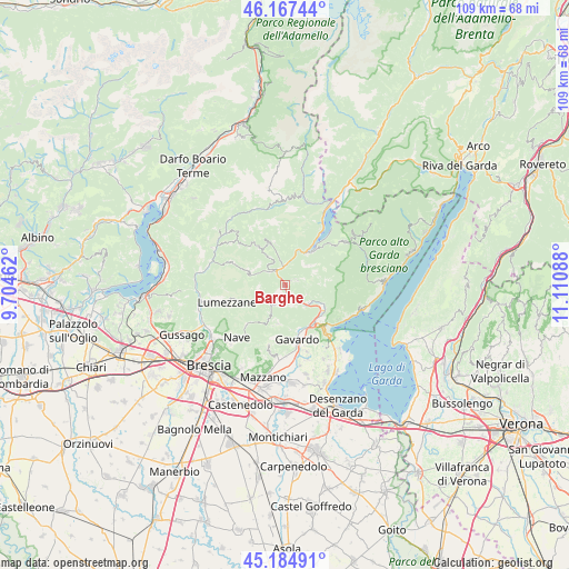
Barghe GPS coordinates[2]
45° 40' 41.988" North, 10° 24' 27.9" East
| Map corner | latitude | longitude |
|---|---|---|
| Upper-left | 46.16744°, | 9.70462° |
| Center: | 45.67833°, | 10.40775° |
| Lower-right: | 45.18491°, | 11.11088° |
| Map W x H: | 109.2×109.2 km | = 67.9×67.9mi |
| max Lat: | 47.04031° ⇑19.8% North |
| Barghe: | 45.67833° |
| min Lat: | ⇓80.2% South 35.50142° |
| min Long | Barghe | max Long |
| 6.69888° | 10.40775° | 18.48682° |
| W 36.1%⇐ | ⇒63.9% E |
Elevation
Elevation of Barghe is 293 m = 961 ft, and this is 13.7 m = 45 ft below average elevation for this country.
| Max E: |
2085 m = 6841 ft | 40.9% |
| Avg. | 306.7 m = 1006 ft | |
| Barghe | 293 m = 961 ft | |
Min E: |
-4 m = -13 ft | 59.1% |
See also: Italy elevation on elevation.city.
Geographical zone
Barghe is located in North temperate zone (between Tropic of Cancer and the Arctic Circle). Distance of this North polar circle is 2322.2 km =1442.9 mi to North.| Distance of | km | miles | from Barghe |
|---|---|---|---|
| North Pole | 4928.1 | 3062.2 | to North |
| Arctic Circle | 2322.2 | 1442.9 | to North |
| Tropic Cancer | 2473 | 1536.7 | to South |
| Equator | 5079 | 3155.9 | to South |


Nearby cities:
15 places around Barghe: (largest is in red/bold)
• Agnosine
5.3 km =3.3 mi,  233°
233°
• Bione
5.4 km =3.4 mi,  263°
263°
• Carpeneda
5.7 km =3.5 mi,  125°
125°
• Casto
7 km =4.3 mi,  285°
285°
• Cedessano
2.3 km =1.4 mi,  60°
60°
• Gazzane
3.2 km =2 mi,  223°
223°
• Mura
6.4 km =4 mi,  307°
307°
• Odolo
4.1 km =2.5 mi,  207°
207°
• Preseglie
1.4 km =0.9 mi, 217°
• Provaglio Val Sabbia
2.3 km =1.4 mi, 60°
• Sabbio Chiese
2.7 km =1.7 mi,  156°
156°
• San Faustino
5.1 km =3.2 mi,  254°
254°
• Sottocastello
1.6 km =1 mi, 220°
• Trebbio
5.7 km =3.5 mi,  47°
47°
• Vestone
3.4 km =2.1 mi,  344°
344°
Sources, notices
• [Note1] Compared only with cities in Italy existing in our database
• [Src1] Map data: © OpenStreetMap contributors (CC-BY-SA)
• [Src2] Other city data from geonames.org with taken over terms of usage.
• [Src3] Geographical zone / Annual Mean Temperature by Robert A. Rohde @ Wikipedia
