Longi geodata
Longi (Sicily) is a seat of a third-order administrative division; located in Italy in Europe/Rome (GMT+2) time zone. With population of 1,514 people, there are 5086 cities with bigger population in this country. Compared to other cities in Italy, 96.4% of cities are located further ↑North; 85% of cities are located further ←West and 85% of cities have lower elevation than Longi. Note1


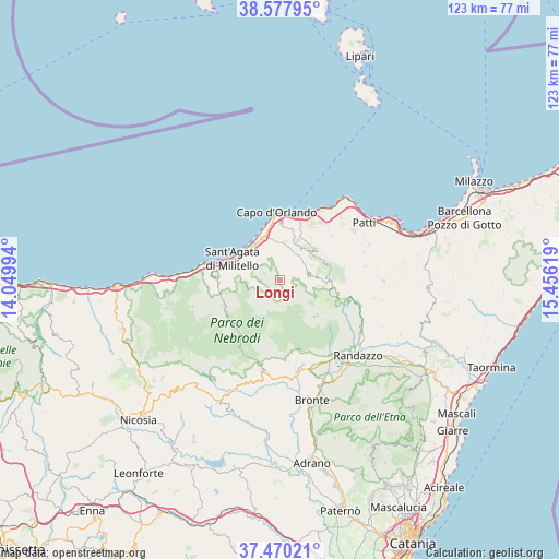
Longi GPS coordinates[2]
38° 1' 34.212" North, 14° 45' 11.016" East
| Map corner | latitude | longitude |
|---|---|---|
| Upper-left | 38.57795°, | 14.04994° |
| Center: | 38.02617°, | 14.75306° |
| Lower-right: | 37.47021°, | 15.45619° |
| Map W x H: | 123.2×123.2 km | = 76.6×76.6mi |
| max Lat: | 47.04031° ⇑96.4% North |
| Longi: | 38.02617° |
| min Lat: | ⇓3.6% South 35.50142° |
| min Long | Longi | max Long |
| 6.69888° | 14.75306° | 18.48682° |
| W 85%⇐ | ⇒15% E |
Elevation
Elevation of Longi is 613 m = 2011 ft, and this is 306.3 m = 1005 ft above average elevation for this country.
| Max E: |
2085 m = 6841 ft | 15% |
| Longi | 613 m 2011 ft | |
| Avg. | 306.7 m = 1006 ft | |
Min E: |
-4 m = -13 ft | 85% |
See also: Italy elevation on elevation.city.
Geographical zone
Longi is located in North temperate zone (between Tropic of Cancer and the Arctic Circle). Distance of this Northern Tropic circle is 1622.2 km =1008 mi to South.| Distance of | km | miles | from Longi |
|---|---|---|---|
| North Pole | 5778.9 | 3590.8 | to North |
| Arctic Circle | 3173.1 | 1971.7 | to North |
| Tropic Cancer | 1622.2 | 1008 | to South |
| Equator | 4228.1 | 2627.2 | to South |


Nearby cities:
15 places around Longi: (largest is in red/bold)
• Alcara Li Fusi
4.6 km =2.9 mi,  263°
263°
• Capri Leone
7 km =4.3 mi,  343°
343°
• Castell'Umberto
8.2 km =5.1 mi,  35°
35°
• Frazzanò
5.2 km =3.2 mi,  351°
351°
• Galati Mamertino
1.7 km =1.1 mi,  68°
68°
• Militello Rosmarino
7.1 km =4.4 mi,  287°
287°
• Mirto
6.5 km =4 mi, 354°
• Rocca di Capri Leone
9.7 km =6 mi, 337°
• San Basilio
2.5 km =1.6 mi,  115°
115°
• San Marco d'Alunzio
6.9 km =4.3 mi,  318°
318°
• San Salvatore di Fitalia
5.2 km =3.2 mi,  24°
24°
• Sfaranda
7.7 km =4.8 mi,  62°
62°
• Sinagra
10.5 km =6.5 mi,  53°
53°
• Torrenova
9.8 km =6.1 mi, 318°
• Tortorici
6.1 km =3.8 mi,  86°
86°
Sources, notices
• [Note1] Compared only with cities in Italy existing in our database
• [Src1] Map data: © OpenStreetMap contributors (CC-BY-SA)
• [Src2] Other city data from geonames.org with taken over terms of usage.
• [Src3] Geographical zone / Annual Mean Temperature by Robert A. Rohde @ Wikipedia
