Valstrona geodata
Valstrona (Piedmont) is a seat of a third-order administrative division; located in Italy in Europe/Rome (GMT+2) time zone. With population of 1,270 people, there are 5725 cities with bigger population in this country. Compared to other cities in Italy, 89.4% of cities are located further ↓South; 89.6% of cities are located further →East and 79.3% of cities have lower elevation than Valstrona. Note1
Administrative division(s):
- Level 1: Piedmont
- Level 2: Provincia Verbano-Cusio-Ossola
- Level 3: Valstrona


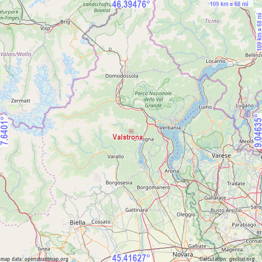
Valstrona GPS coordinates[2]
45° 54' 27.612" North, 8° 20' 35.592" East
| Map corner | latitude | longitude |
|---|---|---|
| Upper-left | 46.39476°, | 7.6401° |
| Center: | 45.90767°, | 8.34322° |
| Lower-right: | 45.41627°, | 9.04635° |
| Map W x H: | 108.8×108.8 km | = 67.6×67.6mi |
| max Lat: | 47.04031° ⇑10.6% North |
| Valstrona: | 45.90767° |
| min Lat: | ⇓89.4% South 35.50142° |
| min Long | Valstrona | max Long |
| 6.69888° | 8.34322° | 18.48682° |
| W 10.4%⇐ | ⇒89.6% E |
Elevation
Elevation of Valstrona is 514 m = 1686 ft, and this is 207.3 m = 680 ft above average elevation for this country.
| Max E: |
2085 m = 6841 ft | 20.7% |
| Valstrona | 514 m 1686 ft | |
| Avg. | 306.7 m = 1006 ft | |
Min E: |
-4 m = -13 ft | 79.3% |
See also: Italy elevation on elevation.city.
Geographical zone
Valstrona is located in North temperate zone (between Tropic of Cancer and the Arctic Circle). Distance of this North polar circle is 2296.7 km =1427.1 mi to North.| Distance of | km | miles | from Valstrona |
|---|---|---|---|
| North Pole | 4902.6 | 3046.3 | to North |
| Arctic Circle | 2296.7 | 1427.1 | to North |
| Tropic Cancer | 2498.5 | 1552.5 | to South |
| Equator | 5104.5 | 3171.8 | to South |


Nearby cities:
15 places around Valstrona: (largest is in red/bold)
• Agrano
8.8 km =5.5 mi,  140°
140°
• Anzola d'Ossola
9 km =5.6 mi,  1°
1°
• Casale Corte Cerro
5.5 km =3.4 mi,  81°
81°
• Cesara
8.4 km =5.2 mi,  166°
166°
• Gabbio-Cereda-Ramate
6 km =3.7 mi,  87°
87°
• Germagno
3.8 km =2.4 mi,  115°
115°
• Gravellona Toce
7.3 km =4.5 mi,  71°
71°
• Loreglia
2.2 km =1.4 mi, 92°
• Massiola
1.9 km =1.2 mi,  286°
286°
• Nonio
7.4 km =4.6 mi,  158°
158°
• Omegna
5.8 km =3.6 mi, 122°
• Ornavasso
8.7 km =5.4 mi,  39°
39°
• Quarna Sopra
4.5 km =2.8 mi,  148°
148°
• Quarna Sotto
4.6 km =2.9 mi, 160°
• Sabbia
10 km =6.2 mi,  235°
235°
Sources, notices
• [Note1] Compared only with cities in Italy existing in our database
• [Src1] Map data: © OpenStreetMap contributors (CC-BY-SA)
• [Src2] Other city data from geonames.org with taken over terms of usage.
• [Src3] Geographical zone / Annual Mean Temperature by Robert A. Rohde @ Wikipedia
