Polonghera geodata
Polonghera (Piedmont) is a seat of a third-order administrative division; located in Italy in Europe/Rome (GMT+2) time zone. With population of 1,128 people, there are 6180 cities with bigger population in this country. Compared to other cities in Italy, 56.2% of cities are located further ↓South; 97.1% of cities are located further →East and 52.2% of cities have lower elevation than Polonghera. Note1


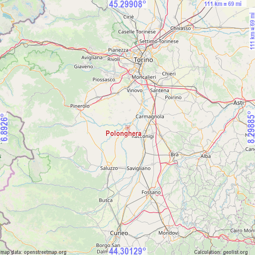
Polonghera GPS coordinates[2]
44° 48' 8.424" North, 7° 35' 44.592" East
| Map corner | latitude | longitude |
|---|---|---|
| Upper-left | 45.29908°, | 6.8926° |
| Center: | 44.80234°, | 7.59572° |
| Lower-right: | 44.30129°, | 8.29885° |
| Map W x H: | 110.9×110.9 km | = 68.9×68.9mi |
| max Lat: | 47.04031° ⇑43.8% North |
| Polonghera: | 44.80234° |
| min Lat: | ⇓56.2% South 35.50142° |
| min Long | Polonghera | max Long |
| 6.69888° | 7.59572° | 18.48682° |
| W 2.9%⇐ | ⇒97.1% E |
Elevation
Elevation of Polonghera is 248 m = 814 ft, and this is 58.7 m = 193 ft below average elevation for this country.
| Max E: |
2085 m = 6841 ft | 47.8% |
| Avg. | 306.7 m = 1006 ft | |
| Polonghera | 248 m = 814 ft | |
Min E: |
-4 m = -13 ft | 52.2% |
See also: Italy elevation on elevation.city.
Geographical zone
Polonghera is located in North temperate zone (between Tropic of Cancer and the Arctic Circle). Distance of this Northern Tropic circle is 2375.6 km =1476.1 mi to South.| Distance of | km | miles | from Polonghera |
|---|---|---|---|
| North Pole | 5025.5 | 3122.7 | to North |
| Arctic Circle | 2419.6 | 1503.5 | to North |
| Tropic Cancer | 2375.6 | 1476.1 | to South |
| Equator | 4981.6 | 3095.4 | to South |


Nearby cities:
15 places around Polonghera: (largest is in red/bold)
• Casalgrasso
2.9 km =1.8 mi,  52°
52°
• Cavallerleone
8.8 km =5.5 mi,  142°
142°
• Faule
0.9 km =0.6 mi,  297°
297°
• Lombriasco
5.3 km =3.3 mi,  36°
36°
• Moretta
6.5 km =4 mi,  225°
225°
• Murello
5.6 km =3.5 mi,  175°
175°
• Osasio
7.7 km =4.8 mi,  7°
7°
• Pancalieri
3.5 km =2.2 mi,  347°
347°
• Piobesi Torinese
4.3 km =2.7 mi,  157°
157°
• Racconigi
7.7 km =4.8 mi,  121°
121°
• Torre San Giorgio
9.1 km =5.7 mi,  215°
215°
• Vigone
8.9 km =5.5 mi, 299°
• Villafranca Piemonte
7.1 km =4.4 mi,  257°
257°
• Villanova Solaro
8.2 km =5.1 mi,  191°
191°
• Virle Piemonte
7.1 km =4.4 mi,  343°
343°
Sources, notices
• [Note1] Compared only with cities in Italy existing in our database
• [Src1] Map data: © OpenStreetMap contributors (CC-BY-SA)
• [Src2] Other city data from geonames.org with taken over terms of usage.
• [Src3] Geographical zone / Annual Mean Temperature by Robert A. Rohde @ Wikipedia
